Photographic Print > Asia > Vietnam > Maps
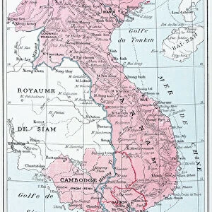
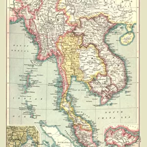
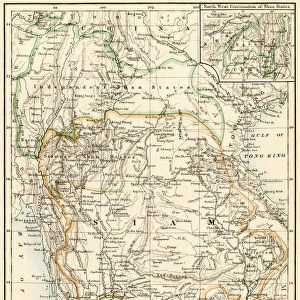
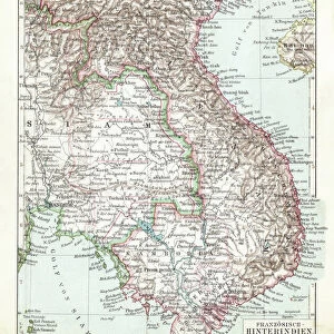
Photographic Print : Map of Thailand and Vietnam 1900


![]()
Photo Prints from Fine Art Storehouse
Map of Thailand and Vietnam 1900
Meyers hand-Atlas Leipzig und Wien Verlag des Bibliographischen Instituts 1900
Unleash your creativity and transform your space into a visual masterpiece!
THEPALMER
Media ID 18106939
© 2014 Roberto Adrian Photography
10"x8" (25x20cm) Photo Print
Step back in time with our exquisite 'Map of Thailand and Vietnam 1900' print from THEPALMER's Fine Art Storehouse collection. This stunning vintage map, originally published in the Meyers Hand-Atlas by Bibliographisches Institut Leipzig und Wien Verlag, offers a captivating glimpse into the historical geography of Southeast Asia over a century ago. Each print is meticulously reproduced to preserve the intricate details and authentic antique charm, making it a unique and captivating addition to any home or office decor. Bring history to life with this exquisite piece of fine art.
Ideal for framing, Australian made Photo Prints are produced on high-quality 270 gsm lustre photo paper which has a subtle shimmer adding a touch of elegance, designed to enhance their visual appeal.
Our Photo Prints are in a large range of sizes and are printed on Archival Quality Paper for excellent colour reproduction and longevity. They are ideal for framing (our Framed Prints use these) at a reasonable cost. Alternatives include cheaper Poster Prints and higher quality Fine Art Paper, the choice of which is largely dependant on your budget.
Estimated Image Size (if not cropped) is 18.1cm x 25.4cm (7.1" x 10")
Estimated Product Size is 20.3cm x 25.4cm (8" x 10")
These are individually made so all sizes are approximate
Artwork printed orientated as per the preview above, with portrait (vertical) orientation to match the source image.
FEATURES IN THESE COLLECTIONS
> Fine Art Storehouse
> Map
> Historical Maps
> Asia
> Thailand
> Related Images
> Asia
> Turkmenistan
> Maps
> Asia
> Vietnam
> Related Images
EDITORS COMMENTS
In this print titled "Map of Thailand and Vietnam 1900" we are transported back in time to the turn of the 20th century. The image, sourced from Meyers hand-Atlas Leipzig und Wien Verlag des Bibliographischen Instituts in 1900, offers a glimpse into the intricate cartography techniques employed during that era. The map showcases the detailed boundaries and topographical features of both Thailand and Vietnam as they stood over a century ago. Every contour line, river system, and city is meticulously etched onto the aged parchment-like paper. It serves as a testament to the dedication and precision required by cartographers at that time. As we observe this historical artifact through THEPALMER's lens, we can't help but marvel at how much these regions have evolved since then. The political landscape has shifted drastically, borders redrawn, cities expanded or renamed – reminding us of our ever-changing world. Beyond its geographical significance lies an artistic charm within this vintage print. The sepia tones evoke nostalgia while adding depth to each intricately drawn detail. This piece would make an exquisite addition to any collection or serve as a conversation starter when displayed prominently on one's wall. "Map of Thailand and Vietnam 1900" invites us to appreciate not only the beauty found in old-world craftsmanship but also sparks curiosity about our shared history and how it has shaped these nations into what they are today.
MADE IN AUSTRALIA
Safe Shipping with 30 Day Money Back Guarantee
FREE PERSONALISATION*
We are proud to offer a range of customisation features including Personalised Captions, Color Filters and Picture Zoom Tools
SECURE PAYMENTS
We happily accept a wide range of payment options so you can pay for the things you need in the way that is most convenient for you
* Options may vary by product and licensing agreement. Zoomed Pictures can be adjusted in the Cart.