Photographic Print > North America > United States of America > Louisiana > New Orleans
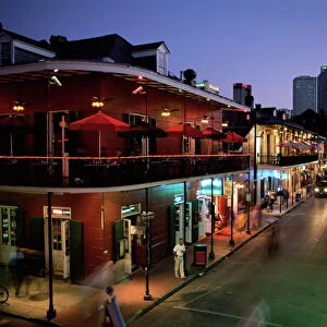
Photographic Print : New Orleans Louisiana map 1898


![]()
Photo Prints from Fine Art Storehouse
New Orleans Louisiana map 1898
Map from the Complete Handy Atlas of the World - 1898
Unleash your creativity and transform your space into a visual masterpiece!
THEPALMER
Media ID 20249931
© A 2014 Roberto Adrian Photography
12"x8" (30x20cm) Photo Print
Step back in time with our exquisite New Orleans Louisiana Map print from THEPALMER's Complete Handy Atlas of the World (1898) at Media Storehouse. This fine art photograph brings history to life, capturing the intricate details of the map's illustrations. Perfect for adding a touch of vintage charm to your home or office, this print makes a unique and thoughtful gift for history enthusiasts or those with a love for the rich culture of New Orleans. Experience the past in high definition with our premium photographic print, expertly crafted to bring out the intricacies and nuances of the original map.
Ideal for framing, Australian made Photo Prints are produced on high-quality 270 gsm lustre photo paper which has a subtle shimmer adding a touch of elegance, designed to enhance their visual appeal.
Our Photo Prints are in a large range of sizes and are printed on Archival Quality Paper for excellent colour reproduction and longevity. They are ideal for framing (our Framed Prints use these) at a reasonable cost. Alternatives include cheaper Poster Prints and higher quality Fine Art Paper, the choice of which is largely dependant on your budget.
Estimated Product Size is 21.2cm x 31.4cm (8.3" x 12.4")
These are individually made so all sizes are approximate
Artwork printed orientated as per the preview above, with landscape (horizontal) or portrait (vertical) orientation to match the source image.
FEATURES IN THESE COLLECTIONS
> Fine Art Storehouse
> Map
> Historical Maps
> Maps and Charts
> Related Images
> Maps and Charts
> World
> North America
> United States of America
> Louisiana
> New Orleans
EDITORS COMMENTS
This print takes us back in time to the vibrant city of New Orleans, Louisiana, as it stood in 1898. The map featured here is a remarkable piece from the Complete Handy Atlas of the World - 1898, showcasing the intricate details and craftsmanship of cartography during that era. As we gaze upon this vintage treasure by THEPALMER, we are transported to an era when New Orleans was bustling with life and rich cultural heritage. The map captures every nook and cranny of this enchanting city, revealing its labyrinthine streets and iconic landmarks. The fine art quality of this print allows us to appreciate not only the historical significance but also the artistic beauty within each stroke on paper. The delicate lines depict neighborhoods like French Quarter, Garden District, and Marigny with precision while highlighting important sites such as St. Louis Cathedral and Jackson Square. Through this image, we can almost hear the sounds of jazz music echoing through these historic streets or imagine ourselves strolling along the Mississippi River's banks. It serves as a visual testament to New Orleans' resilience over time—a reminder that even after natural disasters or societal changes—this beloved city continues to thrive. Whether you're a history enthusiast or simply captivated by vintage aesthetics, this print offers a unique glimpse into New Orleans' past—an exquisite addition for any art collector or admirer seeking to bring a touch of nostalgia into their space.
MADE IN AUSTRALIA
Safe Shipping with 30 Day Money Back Guarantee
FREE PERSONALISATION*
We are proud to offer a range of customisation features including Personalised Captions, Color Filters and Picture Zoom Tools
SECURE PAYMENTS
We happily accept a wide range of payment options so you can pay for the things you need in the way that is most convenient for you
* Options may vary by product and licensing agreement. Zoomed Pictures can be adjusted in the Cart.