Photographic Print > Europe > Italy > Lazio > Rome
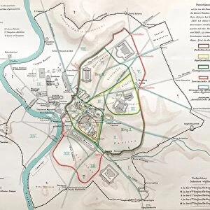
Photographic Print : Floor plan of Palatine Hill in Rome, published in 1878


![]()
Photo Prints from Fine Art Storehouse
Floor plan of Palatine Hill in Rome, published in 1878
Floor plan of the archaeological remains of the Palatine Hill in Rome. The Palatine Hill (Latin: Mons Palatinus, Italian: Monte Palatino) is one of the seven hills of Rome and is the oldest inhabited part of the city. Already in the 10th century BC were found on the Palatine human settlements. Wood engraving, published in 1878
Unleash your creativity and transform your space into a visual masterpiece!
Media ID 13666875
© ZU_09
Ancient History Ancient Rome Blueprint Italian Culture Palate Plan Palatine Hill Roman Republic
10"x8" (25x20cm) Photo Print
Step back in time with our exquisite Fine Art Storehouse photographic print of the Floor plan of Palatine Hill in Rome, published in 1878. This rare and captivating image offers a unique glimpse into the ancient world, showcasing the archaeological remains of the Palatine Hill as they were understood over a century ago. Perfect for history enthusiasts, architects, or anyone with an appreciation for the rich heritage of Rome, this fine art print makes a stunning addition to your home or office décor. Experience the timeless beauty and historical significance of this iconic landmark through the lens of history. Order now and bring a piece of the past into your space.
Ideal for framing, Australian made Photo Prints are produced on high-quality 270 gsm lustre photo paper which has a subtle shimmer adding a touch of elegance, designed to enhance their visual appeal.
Our Photo Prints are in a large range of sizes and are printed on Archival Quality Paper for excellent colour reproduction and longevity. They are ideal for framing (our Framed Prints use these) at a reasonable cost. Alternatives include cheaper Poster Prints and higher quality Fine Art Paper, the choice of which is largely dependant on your budget.
Estimated Product Size is 20.3cm x 25.4cm (8" x 10")
These are individually made so all sizes are approximate
Artwork printed orientated as per the preview above, with portrait (vertical) orientation to match the source image.
FEATURES IN THESE COLLECTIONS
> Fine Art Storehouse
> Map
> Historical Maps
> Fine Art Storehouse
> Map
> Italian Maps
> Arts
> Artists
> R
> Roman Roman
> Europe
> Italy
> Lazio
> Rome
> Europe
> Italy
> Related Images
> Historic
> Ancient civilizations
> Maps and Charts
> Early Maps
> Maps and Charts
> Italy
> Maps and Charts
> Related Images
EDITORS COMMENTS
This print showcases the floor plan of Palatine Hill in Rome, published in 1878. The intricate blueprint provides a glimpse into the archaeological remains of this historic site. Known as one of the seven hills of Rome, Palatine Hill holds immense significance as it is considered the oldest inhabited part of the city. Its rich history dates back to the 10th century BC when human settlements were discovered on its grounds. The wood engraving beautifully captures every detail, allowing us to explore and appreciate this ancient civilization's architectural marvels. This engraved image serves as a window into Italy's past, shedding light on its remarkable culture and heritage. The vertical composition emphasizes the grandeur and scale of these old ruins while highlighting their structural intricacies. As we delve into this meticulously crafted map, we are transported back in time, immersing ourselves in Roman Republic-era archaeology. With elements such as cartography and etching skillfully employed, this photograph offers an invaluable resource for historians and enthusiasts alike. It serves as a testament to our fascination with uncovering hidden stories from centuries gone by.
MADE IN AUSTRALIA
Safe Shipping with 30 Day Money Back Guarantee
FREE PERSONALISATION*
We are proud to offer a range of customisation features including Personalised Captions, Color Filters and Picture Zoom Tools
SECURE PAYMENTS
We happily accept a wide range of payment options so you can pay for the things you need in the way that is most convenient for you
* Options may vary by product and licensing agreement. Zoomed Pictures can be adjusted in the Cart.