Photographic Print > Africa > Mali > Maps
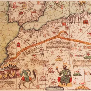
Photographic Print : Mali country map


![]()
Photo Prints from Fine Art Storehouse
Mali country map
2011 edition
Unleash your creativity and transform your space into a visual masterpiece!
Media ID 14432125
15"x10" (37.5x25cm) Poster
High-quality poster prints are available in a range of sizes and are printed on 270 gsm semi-glossy silk finish poster paper. An affordable option for decorating any space, they are perfect for fixing straight onto walls. To ensure your poster arrives in good condition, we roll and send them in strong mailing tubes.
Our Photo Prints are in a large range of sizes and are printed on Archival Quality Paper for excellent colour reproduction and longevity. They are ideal for framing (our Framed Prints use these) at a reasonable cost. Alternatives include cheaper Poster Prints and higher quality Fine Art Paper, the choice of which is largely dependant on your budget.
Estimated Product Size is 37.5cm x 25cm (14.8" x 9.8")
These are individually made so all sizes are approximate
Artwork printed orientated as per the preview above, with landscape (horizontal) or portrait (vertical) orientation to match the source image.
FEATURES IN THESE COLLECTIONS
> Fine Art Storehouse
> Map
> Reference Maps
> Africa
> Mali
> Related Images
> Maps and Charts
> Related Images
EDITORS COMMENTS
This print showcases the intricate details of the Mali country map, specifically the 2011 edition. The Fine Art Storehouse has beautifully captured this piece, allowing viewers to immerse themselves in the rich cultural tapestry that defines this West African nation. The map is a visual testament to Mali's historical significance and geographical diversity. From its bustling capital city of Bamako to the vast Sahara Desert in the north, every corner of this landlocked country is meticulously depicted with precision and artistry. As one gazes upon this print, they are transported on a virtual journey through Mali's diverse landscapes - from fertile river valleys along Niger and Senegal rivers to rugged mountain ranges like Hombori Tondo. The vibrant colors used in this artwork evoke a sense of warmth and vitality that mirrors Mali's lively culture. Beyond its aesthetic appeal, this print serves as an educational tool for those seeking knowledge about Mali's political boundaries, major cities, and natural landmarks. It ignites curiosity about lesser-known regions such as Timbuktu or Djenne while highlighting famous UNESCO World Heritage sites like Djinguereber Mosque. Whether displayed in a classroom or adorning someone's living space, this print offers more than just cartographic information; it encapsulates the spirit of exploration and appreciation for our world's diverse cultures. It reminds us that maps can be gateways to discovery – inviting us to delve deeper into understanding not only Mali but also our interconnected global community.
MADE IN AUSTRALIA
Safe Shipping with 30 Day Money Back Guarantee
FREE PERSONALISATION*
We are proud to offer a range of customisation features including Personalised Captions, Color Filters and Picture Zoom Tools
SECURE PAYMENTS
We happily accept a wide range of payment options so you can pay for the things you need in the way that is most convenient for you
* Options may vary by product and licensing agreement. Zoomed Pictures can be adjusted in the Cart.