Photographic Print > North America > United States of America > New York > New York > Maps
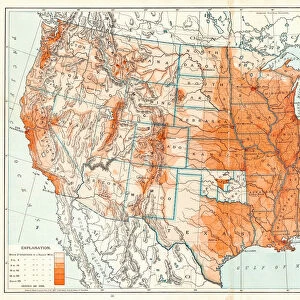
Photographic Print : Map of United States 1895


![]()
Photo Prints from Fine Art Storehouse
Map of United States 1895
The Rand-McNally Grammar School Geography 1895 - Chicago & New York
Unleash your creativity and transform your space into a visual masterpiece!
THEPALMER
Media ID 14824629
© This content is subject to copyright
Canada North America United States
10"x8" (25x20cm) Photo Print
Step back in time with our exquisite 'Map of United States 1895' print from THEPALMER's Fine Art Storehouse collection. This captivating piece, originally published by Rand-McNally for their Grammar School Geography series in Chicago and New York, showcases the United States as it appeared over a century ago. Bring a touch of history and vintage charm to your home or office décor with this intricately detailed and beautifully preserved map print.
Ideal for framing, Australian made Photo Prints are produced on high-quality 270 gsm lustre photo paper which has a subtle shimmer adding a touch of elegance, designed to enhance their visual appeal.
Our Photo Prints are in a large range of sizes and are printed on Archival Quality Paper for excellent colour reproduction and longevity. They are ideal for framing (our Framed Prints use these) at a reasonable cost. Alternatives include cheaper Poster Prints and higher quality Fine Art Paper, the choice of which is largely dependant on your budget.
Estimated Product Size is 25.4cm x 20.3cm (10" x 8")
These are individually made so all sizes are approximate
Artwork printed orientated as per the preview above, with landscape (horizontal) or portrait (vertical) orientation to match the source image.
FEATURES IN THESE COLLECTIONS
> Fine Art Storehouse
> Map
> Historical Maps
> Fine Art Storehouse
> Map
> USA Maps
> Maps and Charts
> Related Images
> North America
> Canada
> Maps
> North America
> Canada
> Related Images
> North America
> Related Images
> North America
> United States of America
> Maps
> North America
> United States of America
> New York
> New York
> Maps
> North America
> United States of America
> New York
> Related Images
EDITORS COMMENTS
In this print titled "Map of United States 1895" we are transported back in time to an era when cartography was a true art form. The Rand-McNally Grammar School Geography of 1895, originating from the bustling cities of Chicago and New York, serves as our guide through the vast expanse of North America. The map itself is a testament to meticulous craftsmanship, showcasing intricate details that bring each state and territory to life. From the jagged coastlines along the Atlantic Ocean to the majestic Rocky Mountains stretching across the continent, every geographical feature is carefully depicted with precision and accuracy. As we delve into this historical masterpiece, it becomes apparent that it holds more than just educational value. It offers a glimpse into an era where exploration and discovery were at their peak. With its vibrant colors and ornate typography, this map not only educates but also ignites our curiosity about what life was like during those times. "The Map of United States 1895" by THEPALMER invites us on a journey through time, allowing us to appreciate both the beauty of cartographic artistry and the rich history embedded within its borders. Whether displayed in classrooms or homes alike, this print serves as a reminder that maps are not merely tools for navigation but windows into our collective past.
MADE IN AUSTRALIA
Safe Shipping with 30 Day Money Back Guarantee
FREE PERSONALISATION*
We are proud to offer a range of customisation features including Personalised Captions, Color Filters and Picture Zoom Tools
SECURE PAYMENTS
We happily accept a wide range of payment options so you can pay for the things you need in the way that is most convenient for you
* Options may vary by product and licensing agreement. Zoomed Pictures can be adjusted in the Cart.