Photographic Print > Fine Art Storehouse > Map
Photographic Print : Pennsylvania state USA map 1881


![]()
Photo Prints from Fine Art Storehouse
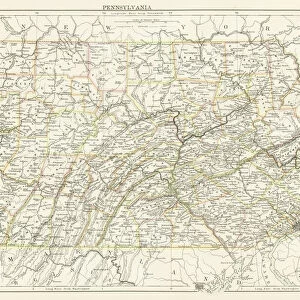
Pennsylvania state USA map 1881
Harpers School Geography, New York, Harpers and Brothers, 1881
Unleash your creativity and transform your space into a visual masterpiece!
THEPALMER
Media ID 14756084
© This content is subject to copyright
Pennsylvania Philadelphia Pittsburgh Appalachian Mountains Harrisburg
15"x10" (37.5x25cm) Poster
Step back in time with our exquisite antique map print from ThePalmer's Harpers School Geography, published in New York by Harpers and Brothers in 1881. This fascinating representation of Pennsylvania's geography from over a century ago, featuring intricate details and beautiful cartography, is now available as a high-quality photographic print from Media Storehouse's Fine Art Storehouse collection. Bring history into your home or office and add a unique touch to your decor with this captivating piece of American history.
High-quality poster prints are available in a range of sizes and are printed on 270 gsm semi-glossy silk finish poster paper. An affordable option for decorating any space, they are perfect for fixing straight onto walls. To ensure your poster arrives in good condition, we roll and send them in strong mailing tubes.
Our Photo Prints are in a large range of sizes and are printed on Archival Quality Paper for excellent colour reproduction and longevity. They are ideal for framing (our Framed Prints use these) at a reasonable cost. Alternatives include cheaper Poster Prints and higher quality Fine Art Paper, the choice of which is largely dependant on your budget.
Estimated Image Size (if not cropped) is 37.5cm x 21.4cm (14.8" x 8.4")
Estimated Product Size is 37.5cm x 25cm (14.8" x 9.8")
These are individually made so all sizes are approximate
Artwork printed orientated as per the preview above, with landscape (horizontal) orientation to match the source image.
FEATURES IN THESE COLLECTIONS
> Fine Art Storehouse
> Map
> Historical Maps
> Fine Art Storehouse
> Map
> USA Maps
EDITORS COMMENTS
This print showcases a vintage map of Pennsylvania, USA, dating back to the year 1881. Taken from Harpers School Geography in New York and published by Harpers and Brothers, this historical piece offers a glimpse into the state's past. The intricate details on the map highlight various significant landmarks and cities such as Harrisburg, Philadelphia, Pittsburgh, and the majestic Appalachian Mountains. The artist behind this remarkable creation is known as THEPALMER. With their skilled eye for detail and appreciation for history, they have expertly captured this piece of cartographic artistry. The fine craftsmanship evident in every line and stroke brings forth an air of nostalgia that transports viewers back to a time long gone. As you gaze upon this exquisite print, you can't help but be drawn into its rich narrative. It serves as a reminder of Pennsylvania's vibrant heritage and its role in shaping American history. Whether you're a native Pennsylvanian or simply fascinated by historical maps, this artwork will undoubtedly spark curiosity about the state's past. Displaying "Pennsylvania State USA Map 1881" proudly on your wall not only adds an elegant touch to your decor but also serves as a conversation starter among friends and family. Let it serve as a testament to our collective fascination with exploration, geography, and the timeless beauty found within antique cartography.
MADE IN AUSTRALIA
Safe Shipping with 30 Day Money Back Guarantee
FREE PERSONALISATION*
We are proud to offer a range of customisation features including Personalised Captions, Color Filters and Picture Zoom Tools
SECURE PAYMENTS
We happily accept a wide range of payment options so you can pay for the things you need in the way that is most convenient for you
* Options may vary by product and licensing agreement. Zoomed Pictures can be adjusted in the Cart.