Photographic Print > Europe > France > Paris > Maps
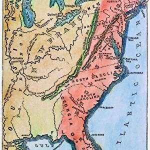
Photographic Print : Map of North America, Illustrating the American War of Independence, c1785, (1890)
")
![]()
Photo Prints from Heritage Images
Map of North America, Illustrating the American War of Independence, c1785, (1890)
Map of North America, Illustrating the American War of Independence, c1785, (1890). The American Revolutionary War (1775-1783) or American War of Independence between Great Britain and its Thirteen Colonies (allied with France) who declared independence in 1776. From " Cassells Illustrated Universal History, Vol. IV - Modern History", by Edmund Ollier. [Cassell and Company, Limited, London, Paris and Melbourne, 1890]
Heritage Images features heritage image collections
Media ID 19126703
© The Print Collector/Heritage Images
American Revolution 1775 1783 American Revolutionary War American War Of Independence 1775 1783 Cassells Cassells Illustrated Universal History Co Cassell Colony Edmund Edmund Ollier Great Britain Imperial Imperialism Independence Modern History New World North America Ollier Ollier Edmund Cassell And Company Ltd Thirteen Colonies
15"x10" (37.5x25cm) Poster
Step back in time with our vintage Map of North America, Illustrating the American War of Independence, from the Media Storehouse collection at Heritage Images. This intricately detailed map, created in 1890, offers a captivating glimpse into the historical landscape of the American Revolutionary War (1775-1783). The map illustrates the key battlegrounds, territories, and political divisions of the time, making it an essential addition to any history or cartography enthusiast's collection. Bring the past to life with this beautiful, antique print.
High-quality poster prints are available in a range of sizes and are printed on 270 gsm semi-glossy silk finish poster paper. An affordable option for decorating any space, they are perfect for fixing straight onto walls. To ensure your poster arrives in good condition, we roll and send them in strong mailing tubes.
Our Photo Prints are in a large range of sizes and are printed on Archival Quality Paper for excellent colour reproduction and longevity. They are ideal for framing (our Framed Prints use these) at a reasonable cost. Alternatives include cheaper Poster Prints and higher quality Fine Art Paper, the choice of which is largely dependant on your budget.
Estimated Image Size (if not cropped) is 22.6cm x 37.5cm (8.9" x 14.8")
Estimated Product Size is 25cm x 37.5cm (9.8" x 14.8")
These are individually made so all sizes are approximate
Artwork printed orientated as per the preview above, with portrait (vertical) orientation to match the source image.
FEATURES IN THESE COLLECTIONS
> Arts
> Literature
> Arts
> Minimalist artwork
> Monochrome artwork
> Modern art
> Europe
> France
> Paris
> Maps
> Historic
> Colonial America illustrations
> American colonies
> Historic
> Colonial America illustrations
> Colonial America
> Historic
> Colonial history
> Colonial art and artists
EDITORS COMMENTS
This print captures a fascinating piece of history - the "Map of North America, Illustrating the American War of Independence" from 1785. The map, originally published in 1890 as part of "Cassells Illustrated Universal History" provides a visual representation of the American Revolutionary War (1775-1783) or American War of Independence. The map showcases Great Britain and its Thirteen Colonies, which had declared independence in 1776 and were supported by France during this historic conflict. It offers a close-up view that allows us to examine the colonial territories, locations, and borders during this tumultuous period. With its antique charm and monochrome aesthetic, this print transports us back to the 19th century when imperialism was at its height. It serves as a reminder of how nations like Great Britain sought to expand their empires across the world while encountering resistance from those seeking freedom and independence. As we explore this piece, we are invited to reflect on the significance of rebellion and revolution in shaping our modern world. This map not only represents an important chapter in American history but also highlights broader themes such as colonialism, imperialism, literature, and art. Preserved by The Print Collector's collection with unknown authorship details available for public viewing through Heritage Images platform; it stands as an invaluable resource for historians, scholars, or anyone interested in delving into North America's past.
MADE IN AUSTRALIA
Safe Shipping with 30 Day Money Back Guarantee
FREE PERSONALISATION*
We are proud to offer a range of customisation features including Personalised Captions, Color Filters and Picture Zoom Tools
SECURE PAYMENTS
We happily accept a wide range of payment options so you can pay for the things you need in the way that is most convenient for you
* Options may vary by product and licensing agreement. Zoomed Pictures can be adjusted in the Cart.