Photographic Print > Europe > United Kingdom > England > London > Boroughs > Barnet
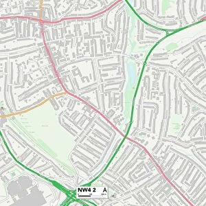
Photographic Print : Barnet N20 9 Map


![]()
Photo Prints from Map Marketing
Barnet N20 9 Map
Postcode Sector Map of Barnet N20 9
Media ID 19976117
Applewood Close Barnet Beech Avenue Blakeney Close Buckingham Avenue Downland Close Farnham Close Franklin Close Harrison Close High Road Langton Avenue Oakleigh Avenue Oakleigh Gardens Oxford Gardens St Margarets Avenue Temple Avenue The Firs
10"x8" (25x20cm) Photo Print
Ideal for framing, Australian made Photo Prints are produced on high-quality 270 gsm lustre photo paper which has a subtle shimmer adding a touch of elegance, designed to enhance their visual appeal.
Our Photo Prints are in a large range of sizes and are printed on Archival Quality Paper for excellent colour reproduction and longevity. They are ideal for framing (our Framed Prints use these) at a reasonable cost. Alternatives include cheaper Poster Prints and higher quality Fine Art Paper, the choice of which is largely dependant on your budget.
Estimated Image Size (if not cropped) is 25.4cm x 18.2cm (10" x 7.2")
Estimated Product Size is 25.4cm x 20.3cm (10" x 8")
These are individually made so all sizes are approximate
Artwork printed orientated as per the preview above, with landscape (horizontal) orientation to match the source image.
FEATURES IN THESE COLLECTIONS
> Map Marketing
> Postcode Sector Maps
> N - London N
> Europe
> United Kingdom
> England
> London
> Boroughs
> Barnet
MADE IN AUSTRALIA
Safe Shipping with 30 Day Money Back Guarantee
FREE PERSONALISATION*
We are proud to offer a range of customisation features including Personalised Captions, Color Filters and Picture Zoom Tools
SECURE PAYMENTS
We happily accept a wide range of payment options so you can pay for the things you need in the way that is most convenient for you
* Options may vary by product and licensing agreement. Zoomed Pictures can be adjusted in the Cart.