Photographic Print > Maps and Charts > Related Images
Photographic Print : Cooks Map of Tahiti


![]()
Photo Prints from Mary Evans Picture Library
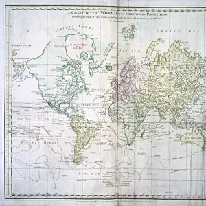
Cooks Map of Tahiti
Cooks map of Tahiti. Date: 1769
Mary Evans Picture Library makes available wonderful images created for people to enjoy over the centuries
Media ID 7111483
© Mary Evans Picture Library 2015 - https://copyrighthub.org/s0/hub1/creation/maryevans/MaryEvansPictureID/10011953
15"x10" (37.5x25cm) Poster
Discover the rich history of Polynesian exploration with our exquisite selection of Media Storehouse Photographic Prints featuring the iconic Cook's Map of Tahiti. Dated 1769, this captivating image from Mary Evans Prints Online brings to life the intrigue and adventure of Captain James Cook's groundbreaking voyage to the South Pacific. Each print is meticulously reproduced in high-quality, bringing the intricate details of the map and the vibrant colors to life. Ideal for adding a touch of history and character to your home or office, these prints make for a stunning addition to any decor. Order yours today and embark on a journey through time.
High-quality poster prints are available in a range of sizes and are printed on 270 gsm semi-glossy silk finish poster paper. An affordable option for decorating any space, they are perfect for fixing straight onto walls. To ensure your poster arrives in good condition, we roll and send them in strong mailing tubes.
Our Photo Prints are in a large range of sizes and are printed on Archival Quality Paper for excellent colour reproduction and longevity. They are ideal for framing (our Framed Prints use these) at a reasonable cost. Alternatives include cheaper Poster Prints and higher quality Fine Art Paper, the choice of which is largely dependant on your budget.
Estimated Image Size (if not cropped) is 37.5cm x 22.5cm (14.8" x 8.9")
Estimated Product Size is 37.5cm x 25cm (14.8" x 9.8")
These are individually made so all sizes are approximate
Artwork printed orientated as per the preview above, with landscape (horizontal) orientation to match the source image.
EDITORS COMMENTS
Cook's Map of Tahiti: A Testament to Pacific Exploration in 1769 This print depicts Captain James Cook's detailed chart of the island of Tahiti, created during his historic voyage to the Pacific Ocean in 1769. Cook, a British explorer and navigator, is renowned for his groundbreaking discoveries and explorations in the Pacific. The map, titled 'A Plan of the Harbour of Matavai in the Island of Otaheite,' offers a fascinating glimpse into the geographical knowledge of the time. Cook's meticulous charting of the harbor and surrounding area reflects the advancements in cartography and navigational techniques during the Age of Discovery. The image reveals the natural beauty of Tahiti, with its lush vegetation, pristine beaches, and crystal-clear waters. Cook's expedition marked a significant turning point in the European exploration of the Pacific, leading to further discoveries, cultural exchanges, and the establishment of colonial outposts in the region. The events of Cook's visit to Tahiti are well-documented in historical records. He arrived in the island's waters in June 1769, seeking refuge from a violent storm. Cook's interactions with the native Tahitians were marked by curiosity, fascination, and ultimately, tragedy. Cook's men encountered the Tahitians' unique culture, including their religious practices, social customs, and artistic traditions. Despite the initial peaceful encounters, tensions escalated, leading to a violent confrontation between Cook's crew and the Tahitians in February 1779. Cook was fatally wounded during the skirmish and died shortly thereafter. This tragic event marked the end of Cook's Pacific voyages, but his legacy as an explorer and cartographer lived on, forever changing the world's understanding of the vast Pacific Ocean and its islands.
MADE IN AUSTRALIA
Safe Shipping with 30 Day Money Back Guarantee
FREE PERSONALISATION*
We are proud to offer a range of customisation features including Personalised Captions, Color Filters and Picture Zoom Tools
SECURE PAYMENTS
We happily accept a wide range of payment options so you can pay for the things you need in the way that is most convenient for you
* Options may vary by product and licensing agreement. Zoomed Pictures can be adjusted in the Cart.