Photographic Print > Europe > United Kingdom > England > London > Boroughs > Camden
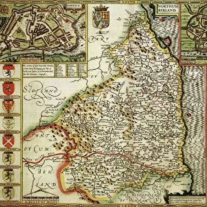
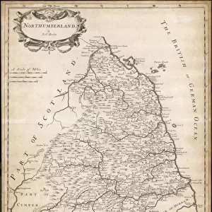
Photographic Print : Map of Northumberland


![]()
Photo Prints from Mary Evans Picture Library
Map of Northumberland
Map of the English county of Northumberland by Robert Morden, originally produced for the 1695 edition of Camdens Britannia
Mary Evans Picture Library makes available wonderful images created for people to enjoy over the centuries
Media ID 4427055
© Mary Evans Picture Library 2015 - https://copyrighthub.org/s0/hub1/creation/maryevans/MaryEvansPictureID/10269031
Britannia Maps Morden North Umberland
10"x8" (25x20cm) Photo Print
Discover the rich history and beauty of Northumberland with our exquisite Media Storehouse Photographic Print of the county map by Robert Morden, available now. Originally created for the 1695 edition of Camden's Britannia, this detailed and captivating map showcases the intricate topography of Northumberland, with its winding rivers, rolling hills, and historic towns. The intricate lines and vibrant colors bring the past to life, making this a perfect addition to any home or office space. Our high-quality photographic print ensures that every detail is crisp and clear, allowing you to explore the intricacies of this historic map in stunning detail. Order yours today and transport yourself to the heart of Northumberland's history.
Ideal for framing, Australian made Photo Prints are produced on high-quality 270 gsm lustre photo paper which has a subtle shimmer adding a touch of elegance, designed to enhance their visual appeal.
Our Photo Prints are in a large range of sizes and are printed on Archival Quality Paper for excellent colour reproduction and longevity. They are ideal for framing (our Framed Prints use these) at a reasonable cost. Alternatives include cheaper Poster Prints and higher quality Fine Art Paper, the choice of which is largely dependant on your budget.
Estimated Product Size is 20.3cm x 25.4cm (8" x 10")
These are individually made so all sizes are approximate
Artwork printed orientated as per the preview above, with portrait (vertical) orientation to match the source image.
FEATURES IN THESE COLLECTIONS
> Arts
> Artists
> M
> Robert Morden
> Europe
> United Kingdom
> England
> London
> Boroughs
> Camden
> Europe
> United Kingdom
> England
> Maps
> Europe
> United Kingdom
> England
> Northumberland
> Related Images
> Europe
> United Kingdom
> England
> Posters
> Europe
> United Kingdom
> England
> Related Images
> Maps and Charts
> Early Maps
> Maps and Charts
> Related Images
EDITORS COMMENTS
1. Title: "Exploring the Historical Landscapes of Northumberland: A Glimpse into England's Ancient Past through Robert Morden's 1695 Map This print showcases Robert Morden's intricately detailed map of Northumberland, an English county located in the northeastern part of the country. Originally produced for the 1695 edition of Camden's Britannia, this historical map offers a fascinating glimpse into the past, revealing the county's rich tapestry of history and geography. Dating back to the late 17th century, Morden's map of Northumberland is an essential resource for anyone interested in the region's history. The map meticulously depicts the county's natural features, including its rugged coastline, vast moorlands, and the winding River Tweed. It also highlights the numerous castles and fortifications that once guarded the borderlands, such as Bamburgh Castle, Alnwick Castle, and the ruins of Dunstanburgh Castle. The map's historical significance lies in its role as a record of the county's topography and settlement patterns during a time of great change. The 17th century saw the decline of feudalism and the rise of the modern state, and Morden's map reflects the shifting political and social landscape of the time. The map also serves as a testament to the enduring allure of Northumberland's natural beauty and historical significance, which continues to draw visitors from around the world today. In conclusion, this map print of Northumberland by Robert Morden is more than just a pretty decoration for a wall. It is a valuable historical artifact that offers a unique perspective on England's rich past and the evolution of cartography. Whether you are a history buff, a collector of antique maps, or simply someone who appreciates the beauty of the past, this map is sure to captivate and inspire you.
MADE IN AUSTRALIA
Safe Shipping with 30 Day Money Back Guarantee
FREE PERSONALISATION*
We are proud to offer a range of customisation features including Personalised Captions, Color Filters and Picture Zoom Tools
SECURE PAYMENTS
We happily accept a wide range of payment options so you can pay for the things you need in the way that is most convenient for you
* Options may vary by product and licensing agreement. Zoomed Pictures can be adjusted in the Cart.