Photographic Print > Europe > United Kingdom > Wales > Powys > Montgomery
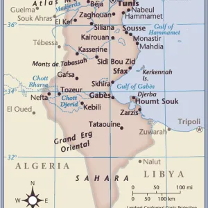
Photographic Print : Mareth Line, Tunisia, by G. H. Davis


![]()
Photo Prints from Mary Evans Picture Library
Mareth Line, Tunisia, by G. H. Davis
A large-scale contour map of the complicated Mareth Line in Tunisia, North Africa, where General Montgomery stated that the enemys fate would be decided. It was the tactical objective of Allied operations at this stage of the Second World War. Date: 1943
Mary Evans Picture Library makes available wonderful images created for people to enjoy over the centuries
Media ID 14125816
© Illustrated London News Ltd/Mary Evans
1943 Allied Allies Contour Davis Decided Djerba Enemy Fate Germans Gulf Maps Montgomery Operations Scale Strategy Tactical Tunisia Tunisian Gabes Objective
10"x8" (25x20cm) Photo Print
Experience the historical depth of war strategy with the captivating photograph "Mareth Line, Tunisia, by G. H. Davis" from Media Storehouse's range of Photographic Prints. This evocative image, sourced from Mary Evans Prints Online, showcases a large-scale contour map of the intricate Mareth Line in North Africa. Witness the complexity of this strategic fortification, where General Montgomery famously declared that the enemy's fate would be decided. Bring history into your home or office with this striking and informative print, a perfect addition to any space dedicated to military history or world geography.
Ideal for framing, Australian made Photo Prints are produced on high-quality 270 gsm lustre photo paper which has a subtle shimmer adding a touch of elegance, designed to enhance their visual appeal.
Our Photo Prints are in a large range of sizes and are printed on Archival Quality Paper for excellent colour reproduction and longevity. They are ideal for framing (our Framed Prints use these) at a reasonable cost. Alternatives include cheaper Poster Prints and higher quality Fine Art Paper, the choice of which is largely dependant on your budget.
Estimated Image Size (if not cropped) is 18.8cm x 25.4cm (7.4" x 10")
Estimated Product Size is 20.3cm x 25.4cm (8" x 10")
These are individually made so all sizes are approximate
Artwork printed orientated as per the preview above, with portrait (vertical) orientation to match the source image.
FEATURES IN THESE COLLECTIONS
> Africa
> Related Images
> Africa
> Tunisia
> Related Images
> Europe
> France
> Canton
> Allier
> Europe
> France
> Canton
> Landes
> Europe
> United Kingdom
> Wales
> Powys
> Montgomery
> Historic
> World War I and II
> Generals and leaders
> Maps and Charts
> Early Maps
EDITORS COMMENTS
This large-scale contour map, created by G.H. Davis in 1943, depicts the intricate Mareth Line in Tunisia, North Africa, a strategic position that became the tactical objective of Allied operations during the Second World War. The Mareth Line was a series of fortifications and defensive positions extending from the Gulf of Gabes to the Mediterranean Sea, and was the Germans' final defensive line in Tunisia before their retreat. The line was named after the nearby town of Mareth, and was considered a formidable obstacle due to its natural defenses, including mountains, islands, and the Bou Grara and Grara rivers. At the time this map was made, the outcome of the war in North Africa was uncertain, and the fate of the Axis powers in the region was a topic of intense debate. Allied Commander-in-Chief, General Bernard Montgomery, famously declared that the enemy's fate would be decided at the Mareth Line. The Allied forces launched a series of attacks against the position, culminating in the Battle of Wadi Akarit in March 1943, which ultimately led to the German retreat and the end of the Tunisian campaign. This map provides a detailed view of the complex terrain and strategic features of the Mareth Line, including the Djerba Island, the mountains, and the various fortifications and defensive positions. It is an invaluable historical document, offering insights into the military strategy and tactics employed by both sides during the North African campaign of the Second World War.
MADE IN AUSTRALIA
Safe Shipping with 30 Day Money Back Guarantee
FREE PERSONALISATION*
We are proud to offer a range of customisation features including Personalised Captions, Color Filters and Picture Zoom Tools
SECURE PAYMENTS
We happily accept a wide range of payment options so you can pay for the things you need in the way that is most convenient for you
* Options may vary by product and licensing agreement. Zoomed Pictures can be adjusted in the Cart.