Photographic Print > Europe > France > Paris > Maps
Photographic Print : Map of the 17th Arrondissement, Paris, France


![]()
Photo Prints from Mary Evans Picture Library
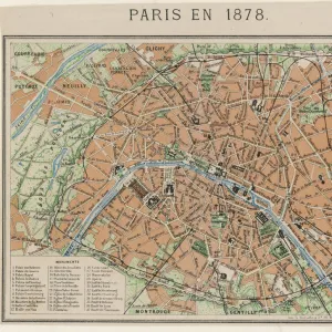
Map of the 17th Arrondissement, Paris, France
Map of the 17th Arrondissement, Quartier des Epinettes, Paris, France. Date: circa 1900s
Mary Evans Picture Library makes available wonderful images created for people to enjoy over the centuries
Media ID 23272426
© Mary Evans Picture Library
Arrondissement Avenue Balagny Bessieres Clichy Epinettes Maps Michel Ouen Quartier Roads
15"x10" (37.5x25cm) Poster
Discover the charm of Paris with our exquisite range of Photographic Prints from Media Storehouse. This stunning representation of the 17th Arrondissement in Paris, France, takes you back in time to the quaint Quartier des Epinettes. Dating back to the 1900s, this vintage map brings history to life with its intricate details and authentic character. Rights Managed through Mary Evans Prints Online, this print is perfect for those seeking a unique and captivating addition to their home or office decor. Bring a piece of Parisian history into your space and let the allure of the City of Light enchant you every day.
High-quality poster prints are available in a range of sizes and are printed on 270 gsm semi-glossy silk finish poster paper. An affordable option for decorating any space, they are perfect for fixing straight onto walls. To ensure your poster arrives in good condition, we roll and send them in strong mailing tubes.
Our Photo Prints are in a large range of sizes and are printed on Archival Quality Paper for excellent colour reproduction and longevity. They are ideal for framing (our Framed Prints use these) at a reasonable cost. Alternatives include cheaper Poster Prints and higher quality Fine Art Paper, the choice of which is largely dependant on your budget.
Estimated Product Size is 37.5cm x 25cm (14.8" x 9.8")
These are individually made so all sizes are approximate
Artwork printed orientated as per the preview above, with landscape (horizontal) or portrait (vertical) orientation to match the source image.
FEATURES IN THESE COLLECTIONS
> Mary Evans Prints Online
> New Images August 2021
> Europe
> France
> Paris
> Maps
> Europe
> France
> Paris
> Related Images
> Maps and Charts
> Related Images
EDITORS COMMENTS
Step back in time with this print of the 17th Arrondissement in Paris, France, circa 1900s. This intricately detailed map showcases the Quartier des Epinettes, a charming and historic neighborhood located in the northwestern part of the city. The map highlights the labyrinthine network of roads and streets that crisscross this picturesque area, including Rue Balagny, Avenue St. Ouen, and Clichy. These thoroughfares have been a part of Parisian life for over a century, connecting the community's residents to the heart of the city. One of the most notable landmarks depicted on the map is the Church of St. Michel-de-Bessières, located at the intersection of Rue Balagny and Rue des Epinettes. This beautiful church, with its distinctive red-tiled roof and ornate facade, has been a spiritual and architectural landmark of the neighborhood for over 150 years. The map also reveals the presence of several markets and commercial areas, such as the famous Marché de St. Ouen, which has been a hub of activity for antique dealers, flea market vendors, and food stalls since the late 1800s. This vintage map offers a fascinating glimpse into the history and character of the 17th Arrondissement, a neighborhood that continues to captivate visitors and locals alike with its rich cultural heritage and unique charm.
MADE IN AUSTRALIA
Safe Shipping with 30 Day Money Back Guarantee
FREE PERSONALISATION*
We are proud to offer a range of customisation features including Personalised Captions, Color Filters and Picture Zoom Tools
SECURE PAYMENTS
We happily accept a wide range of payment options so you can pay for the things you need in the way that is most convenient for you
* Options may vary by product and licensing agreement. Zoomed Pictures can be adjusted in the Cart.