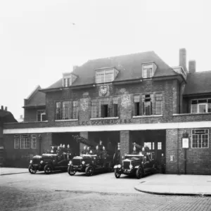
Photographic Print > Europe > United Kingdom > England > London > Fire Brigade
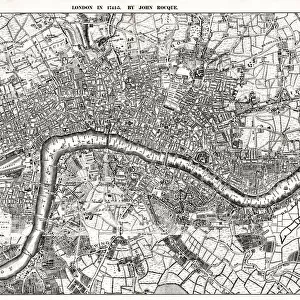
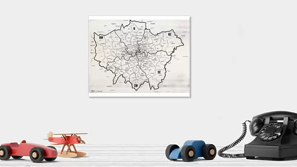
Photographic Print : Map of the Greater London area


![]()
Photo Prints from Mary Evans Picture Library
Map of the Greater London area
Map of the Greater London area with council areas marked. Date: mid-20th century
Mary Evans Picture Library makes available wonderful images created for people to enjoy over the centuries
Media ID 23043928
© London Fire Brigade / Mary Evans Picture Library
Annotated Annotation Area Areas Authorities Authority Berks Buckinghamshire Bucks Council Councils Districts Essex Greater Hertfordshire Herts Maps Marked Postal Surrey
10"x8" (25x20cm) Photo Print
Discover the rich history and intricacies of Greater London with our exquisite Map of the Greater London area print from Media Storehouse. This stunning, rights-managed image, sourced from Mary Evans Prints Online, takes you back to the mid-20th century. With meticulous detail, this map highlights the council areas that once shaped London's diverse communities. Bring a piece of historical London into your home or office space and ignite conversations with this captivating and informative addition to your decor. Order your Map of Greater London print today and embark on a journey through time.
Ideal for framing, Australian made Photo Prints are produced on high-quality 270 gsm lustre photo paper which has a subtle shimmer adding a touch of elegance, designed to enhance their visual appeal.
Our Photo Prints are in a large range of sizes and are printed on Archival Quality Paper for excellent colour reproduction and longevity. They are ideal for framing (our Framed Prints use these) at a reasonable cost. Alternatives include cheaper Poster Prints and higher quality Fine Art Paper, the choice of which is largely dependant on your budget.
Estimated Image Size (if not cropped) is 25.4cm x 18.6cm (10" x 7.3")
Estimated Product Size is 25.4cm x 20.3cm (10" x 8")
These are individually made so all sizes are approximate
Artwork printed orientated as per the preview above, with landscape (horizontal) orientation to match the source image.
FEATURES IN THESE COLLECTIONS
> Mary Evans Prints Online
> New Images August 2021
> Europe
> United Kingdom
> England
> Buckinghamshire
> Related Images
> Europe
> United Kingdom
> England
> Essex
> Related Images
> Europe
> United Kingdom
> England
> Greater London
> Related Images
> Europe
> United Kingdom
> England
> Hertfordshire
> Related Images
> Europe
> United Kingdom
> England
> London
> Fire Brigade
> Europe
> United Kingdom
> England
> London
> Related Images
> Europe
> United Kingdom
> England
> Surrey
> Related Images
> Maps and Charts
> Related Images
EDITORS COMMENTS
This mid-20th century map print of Greater London showcases the administrative divisions of the area, with the London Fire Brigade (LFB) service districts and the boundaries of the various local authorities and councils meticulously marked. The map provides a fascinating glimpse into the historical organization of London's administrative structure during this time. The London Fire Brigade, established in 1865, is responsible for firefighting and emergency medical services in Greater London. The map illustrates the LFB's jurisdiction, which covers the entirety of Greater London, including the City of London and the surrounding boroughs. The map also highlights the various local authorities and councils that governed different areas of Greater London during the mid-20th century. These include the County Boroughs of Bexley, Bromley, Croydon, Dagenham, Dartford, Ealing, Greenwich, Hackney, Haringey, Islington, Lewisham, Merton, Newham, Redbridge, Southwark, Sutton, Tower Hamlets, Wandsworth, and Walthamstow. Additionally, the map shows the County Councils of Surrey, Kent, Essex, Hertfordshire, Buckinghamshire, and Berkshire, which had some responsibilities in the outskirts of Greater London. This annotated map is an essential resource for researchers, historians, and anyone interested in understanding the administrative structure of London during the mid-20th century. It offers valuable insights into the complex web of local government entities that governed the Greater London area and the role of the London Fire Brigade in providing essential services to the community.
MADE IN AUSTRALIA
Safe Shipping with 30 Day Money Back Guarantee
FREE PERSONALISATION*
We are proud to offer a range of customisation features including Personalised Captions, Color Filters and Picture Zoom Tools
SECURE PAYMENTS
We happily accept a wide range of payment options so you can pay for the things you need in the way that is most convenient for you
* Options may vary by product and licensing agreement. Zoomed Pictures can be adjusted in the Cart.