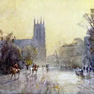
Photographic Print > Maps and Charts > Americas
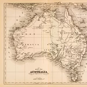
Photographic Print : MAP / NORTH AMERICA 1827


![]()
Photo Prints from Mary Evans Picture Library
MAP / NORTH AMERICA 1827
Map of North America Date: 1827
Mary Evans Picture Library makes available wonderful images created for people to enjoy over the centuries
Media ID 20153845
© Bubblepunk
10"x8" (25x20cm) Photo Print
Discover history through the lens with our exquisite collection of antique maps from Media Storehouse. This captivating print showcases a detailed and intriguing map of North America, dated 1827, sourced from Mary Evans Prints Online. Transport yourself back in time and explore the vast landscapes and territories of North America as they appeared over 200 years ago. A beautiful addition to any home or office, this collectible print is sure to spark curiosity and ignite conversations. Order now and bring a piece of historical cartography into your space.
Ideal for framing, Australian made Photo Prints are produced on high-quality 270 gsm lustre photo paper which has a subtle shimmer adding a touch of elegance, designed to enhance their visual appeal.
Our Photo Prints are in a large range of sizes and are printed on Archival Quality Paper for excellent colour reproduction and longevity. They are ideal for framing (our Framed Prints use these) at a reasonable cost. Alternatives include cheaper Poster Prints and higher quality Fine Art Paper, the choice of which is largely dependant on your budget.
Estimated Product Size is 20.3cm x 25.4cm (8" x 10")
These are individually made so all sizes are approximate
Artwork printed orientated as per the preview above, with portrait (vertical) orientation to match the source image.
FEATURES IN THESE COLLECTIONS
> Mary Evans Prints Online
> America
> Mary Evans Prints Online
> New Images July 2020
> Maps and Charts
> Related Images
> North America
> Related Images
EDITORS COMMENTS
This stunning antique map print, titled "North America" and dated 1827, offers a fascinating glimpse into the cartographic knowledge of the time. The intricately detailed map depicts the North American continent as it was understood during the early 19th century. The map is adorned with various geographical features, including rivers, mountains, and bodies of water, all rendered with a high level of accuracy for the period. The map also includes numerous annotations and labels, providing valuable information about the political divisions of the continent at the time. The map's borders extend from the Arctic Circle in the north to the Gulf of Mexico in the south, and from the Atlantic Ocean in the east to the Pacific Ocean in the west. The map includes the United States, Canada, and Mexico, as well as various territories and colonies. One of the most intriguing aspects of this map is the representation of the western half of North America. At the time, much of this region was still largely unexplored, and the map reflects the limited knowledge of the area. The map includes various speculative labels and boundaries, indicating the uncertainty of the cartographers of the time. Despite these limitations, the map is a testament to the advances in cartography during the early 19th century. The intricate detail and careful labeling demonstrate the dedication and expertise of the mapmakers, who were driven by a desire to accurately represent the world around them. This map is not only a valuable historical document, but also a beautiful work of art. The use of color and shading adds depth and texture to the map, making it a captivating addition to any collection. Whether used for educational purposes or simply as a decorative piece, this map is sure to inspire wonder and curiosity about the history of North America and the world beyond.
MADE IN AUSTRALIA
Safe Shipping with 30 Day Money Back Guarantee
FREE PERSONALISATION*
We are proud to offer a range of customisation features including Personalised Captions, Color Filters and Picture Zoom Tools
SECURE PAYMENTS
We happily accept a wide range of payment options so you can pay for the things you need in the way that is most convenient for you
* Options may vary by product and licensing agreement. Zoomed Pictures can be adjusted in the Cart.