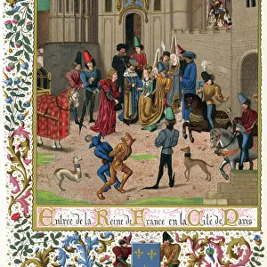
Photographic Print > Europe > France > Paris > Maps
Photographic Print : Times War Atlas - WWI maps


![]()
Photo Prints from Mary Evans Picture Library
Times War Atlas - WWI maps
The Times War Atlas. The atlas contains the following loose maps - 1) Map of the North Sea. 2) Map of the frontiers of France. 3) Map of the North Eastern Theatre of War. 4) Map of the Balkans. 5) Map of the main fortresses of the Western Campaign. 6) Map of the World showing the possessions of the British Empire, France, Germany and her colonies. 7) Map of the area of the European War. 8) War Atlas Gazeteer. 9) Times War Maps which include Poland, Austro-Montenegrin Frontier and the Austro-Italian Frontier. 10) Map of the Western Campaign. 11) Map of Paris and environs. Also includes two copies of The Times Monthly Review of the War dated Wednesday 1st September 1915 and Monday 1st November 1915. Book
Mary Evans Picture Library makes available wonderful images created for people to enjoy over the centuries
Media ID 14153702
© David Cohen Fine Art/Mary Evans Picture Library
Area Atlas Austro Balkans Campaign Colonies Fortresses Frontier Frontiers Include Loose Main Maps Montenegrin Poland Possessions Times Gazeteer
10"x8" (25x20cm) Photo Print
Step back in time with the Times War Atlas - WWI maps from Media Storehouse. This collection, sourced from Mary Evans Prints Online, includes four essential maps from The Times War Atlas. Discover the North Sea's strategic importance with Map 1, explore the frontiers of France in Map 2, delve into the North Eastern Theatre of War in Map 3, and gain insight into the complexities of the Balkans with Map 4. These high-quality, rights-managed prints are perfect for historians, educators, and anyone seeking a deeper understanding of World War I. Bring history to life with the Times War Atlas from Media Storehouse.
Ideal for framing, Australian made Photo Prints are produced on high-quality 270 gsm lustre photo paper which has a subtle shimmer adding a touch of elegance, designed to enhance their visual appeal.
Our Photo Prints are in a large range of sizes and are printed on Archival Quality Paper for excellent colour reproduction and longevity. They are ideal for framing (our Framed Prints use these) at a reasonable cost. Alternatives include cheaper Poster Prints and higher quality Fine Art Paper, the choice of which is largely dependant on your budget.
Estimated Product Size is 20.3cm x 25.4cm (8" x 10")
These are individually made so all sizes are approximate
Artwork printed orientated as per the preview above, with portrait (vertical) orientation to match the source image.
FEATURES IN THESE COLLECTIONS
> Animals
> Mammals
> Muridae
> Western Mouse
> Arts
> Artists
> E
> David Evans
> Europe
> France
> Paris
> Maps
> Europe
> France
> Paris
> Related Images
> Europe
> Italy
> Related Images
EDITORS COMMENTS
This stunning vintage print showcases the Times War Atlas, a comprehensive collection of maps and gazetteers published during World War I. The atlas includes a total of eleven loose maps, each providing valuable insights into the geographical context of the conflict. Among these are maps of the North Sea, the frontiers of France, the North Eastern Theatre of War, the Balkans, the main fortresses of the Western Campaign, and the area of the European War. Additionally, there are maps of Poland, the Austro-Montenegrin Frontier, and the Austro-Italian Frontier. The atlas also features a map of the World showing the possessions of the British Empire, France, and Germany and her colonies, as well as two copies of The Times Monthly Review of the War dated Wednesday 1st September 1915 and Monday 1st November 1915. These historical maps offer a unique perspective into the geopolitical landscape of the time and are an essential resource for scholars, historians, and anyone interested in the history of World War I.
MADE IN AUSTRALIA
Safe Shipping with 30 Day Money Back Guarantee
FREE PERSONALISATION*
We are proud to offer a range of customisation features including Personalised Captions, Color Filters and Picture Zoom Tools
SECURE PAYMENTS
We happily accept a wide range of payment options so you can pay for the things you need in the way that is most convenient for you
* Options may vary by product and licensing agreement. Zoomed Pictures can be adjusted in the Cart.