Photographic Print > Europe > United Kingdom > England > Yorkshire > Wadsley Bridge
Photographic Print : Map of Joseph Machens Farm at Wadsley Bridge, Sheffield, 1790


![]()
Photo Prints from Sheffield City Archives
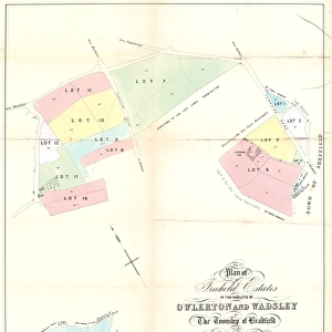
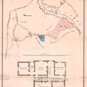
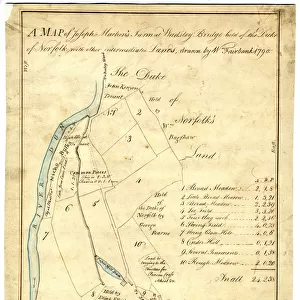
Map of Joseph Machens Farm at Wadsley Bridge, Sheffield, 1790
Full title: A map of Joseph Machens Farm at Wadsley Bridge held of the Duke of Norfolk with other intermediate lands
Scale 4 chains : 1 inch [20 inches : 1 mile].
Surveyor: William Fairbank II.
Fields, farmstead and a paper mill and dam to the south;
From an original at Sheffield Libraries: arc02621
Sheffield City Archives and Local Studies Library has an unrivalled collection of images of Sheffield, England
Media ID 18127443
© Sheffield City Council - All Rights Reserved
10"x8" (25x20cm) Photo Print
Discover the rich history of Sheffield with our exclusive range of Photographic Prints from Sheffield City Archives. This captivating print showcases a rare map of Joseph Machens Farm at Wadsley Bridge, dated 1790. Surveyed by William Fairbank II and held of the Duke of Norfolk, this intricately detailed map offers a glimpse into the past, providing a fascinating insight into the layout and ownership of the land over 200 years ago. Bring a piece of Sheffield's history into your home or office and transport yourself back in time with our high-quality photographic prints.
Ideal for framing, Australian made Photo Prints are produced on high-quality 270 gsm lustre photo paper which has a subtle shimmer adding a touch of elegance, designed to enhance their visual appeal.
Our Photo Prints are in a large range of sizes and are printed on Archival Quality Paper for excellent colour reproduction and longevity. They are ideal for framing (our Framed Prints use these) at a reasonable cost. Alternatives include cheaper Poster Prints and higher quality Fine Art Paper, the choice of which is largely dependant on your budget.
Estimated Product Size is 20.3cm x 25.4cm (8" x 10")
These are individually made so all sizes are approximate
Artwork printed orientated as per the preview above, with landscape (horizontal) or portrait (vertical) orientation to match the source image.
FEATURES IN THESE COLLECTIONS
> Europe
> United Kingdom
> England
> Norfolk
> Related Images
> Europe
> United Kingdom
> England
> South Yorkshire
> Related Images
> Europe
> United Kingdom
> England
> South Yorkshire
> Sheffield
> Europe
> United Kingdom
> England
> Yorkshire
> Related Images
> Europe
> United Kingdom
> England
> Yorkshire
> Sheffield
> Europe
> United Kingdom
> England
> Yorkshire
> Wadsley Bridge
> Maps and Charts
> Related Images
> Sheffield City Archives
> Maps and Plans
EDITORS COMMENTS
This print showcases the historical significance of Joseph Machens Farm at Wadsley Bridge in Sheffield, dating back to 1790. The detailed map, titled "A map of Joseph Machens Farm at Wadsley Bridge held of the Duke of Norfolk with other intermediate lands" provides a fascinating glimpse into the past. Surveyed by William Fairbank II, this meticulously crafted map offers a scale of 4 chains to 1 inch or 20 inches to 1 mile. It beautifully depicts the sprawling fields, farmsteads, and even a paper mill and dam located towards the south. These elements highlight not only the agricultural importance but also industrial activities that shaped this area during that era. Preserved within Sheffield Libraries' archives (arc02621), this remarkable piece serves as an invaluable resource for historians and enthusiasts alike. Its depiction sheds light on how Wadsley Bridge evolved over time and its connection to the River Don. As you admire this photo print, take a moment to appreciate its historical significance and imagine life on Joseph Machens Farm centuries ago. Let it transport you back in time when farming was central to daily life in Yorkshire's vibrant city - Sheffield
MADE IN AUSTRALIA
Safe Shipping with 30 Day Money Back Guarantee
FREE PERSONALISATION*
We are proud to offer a range of customisation features including Personalised Captions, Color Filters and Picture Zoom Tools
SECURE PAYMENTS
We happily accept a wide range of payment options so you can pay for the things you need in the way that is most convenient for you
* Options may vary by product and licensing agreement. Zoomed Pictures can be adjusted in the Cart.