Poster Print > Africa > Zimbabwe > Rhodesia
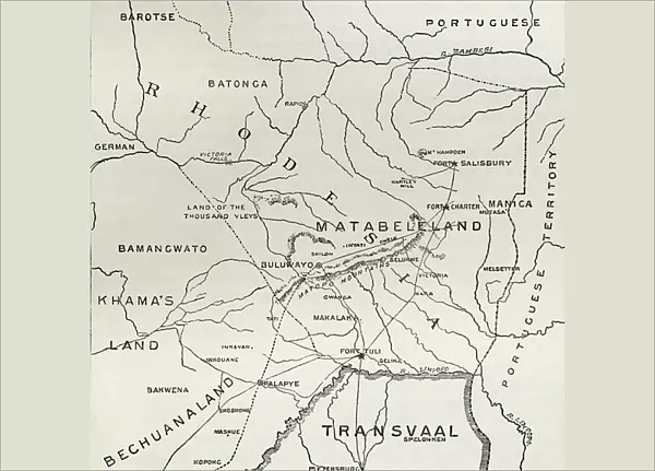
Poster Print : Map of Matabeleland in the late 19th century, from South Africa and the Transvaal War: Vol. 1 by Louis Creswicke, published 1900 (litho)
")


![]()
Poster Prints from Fine Art Finder
Map of Matabeleland in the late 19th century, from South Africa and the Transvaal War: Vol. 1 by Louis Creswicke, published 1900 (litho)
KW371011 Map of Matabeleland in the late 19th century, from South Africa and the Transvaal War: Vol. 1 by Louis Creswicke, published 1900 (litho) by English School, (20th century); Private Collection
Media ID 32180954
© Bridgeman Images
A3 (42 x 29.7cm) Poster Print
Step back in time with our exquisite Map of Matabeleland poster print, taken from the historic volume "South Africa and the Transvaal War: Vol. 1" by Louis Creswicke. Published in 1900, this detailed lithograph offers a captivating glimpse into the late 19th century, showcasing the geography of Matabeleland during the South African and Transvaal Wars. Each print is meticulously reproduced from the original copyrighted work by Ken Welsh from Fine Art Finder, ensuring the highest quality and authenticity. Bring a piece of history into your home or office with this stunning and intriguing poster print.
Premium quality poster prints are printed on luxurious semi-gloss satin 270 gsm paper. Our meticulously crafted poster prints offer an affordable option for decorating any space, making them ideal for living rooms, bedrooms, offices and beyond. To ensure your poster arrives in good condition, we roll and send them in strong mailing tubes.
Poster prints are budget friendly enlarged prints in standard poster paper sizes (A0, A1, A2, A3 etc). Whilst poster paper is sometimes thinner and less durable than our other paper types, they are still ok for framing and should last many years. Our Archival Quality Photo Prints and Fine Art Paper Prints are printed on higher quality paper and the choice of which largely depends on your budget.
Estimated Product Size is 42.6cm x 30.6cm (16.8" x 12")
These are individually made so all sizes are approximate
Artwork printed orientated as per the preview above, with landscape (horizontal) orientation to match the source image.
FEATURES IN THESE COLLECTIONS
> Fine Art Finder
> Artists
> English School
> Fine Art Finder
> Maps (celestial & Terrestrial)
> Africa
> South Africa
> Maps
> Africa
> South Africa
> Related Images
> Africa
> Zimbabwe
> Rhodesia
> Maps and Charts
> Related Images
EDITORS COMMENTS
This lithograph print showcases a historical treasure, the "Map of Matabeleland in the late 19th century". Created by an anonymous English School artist in the early 20th century, this map was originally published in Louis Creswicke's renowned book "South Africa and the Transvaal War: Vol. 1" in 1900. The intricate details depicted on this map offer a fascinating glimpse into the territorial landscape of Matabeleland during that era. Every contour and boundary is meticulously engraved, allowing viewers to explore and understand the region's geography with precision. Matabeleland, located within Rhodesia (now Zimbabwe), holds significant historical importance due to its involvement in various conflicts and colonization efforts. This map serves as a valuable resource for historians, cartographers, and enthusiasts alike who seek to study or trace the evolution of this region over time. Preserved within a private collection, this lithograph print not only captures an important piece of history but also highlights the skillful craftsmanship involved in creating such detailed maps. Its artistic value lies not only in its accuracy but also in its ability to transport us back to a pivotal period when exploration and mapping played crucial roles in shaping our understanding of different territories around the world. With Ken Welsh's copyright stamp ensuring authenticity, this remarkable artwork stands as both an educational tool and a testament to human curiosity about our surroundings throughout history.
MADE IN AUSTRALIA
Safe Shipping with 30 Day Money Back Guarantee
FREE PERSONALISATION*
We are proud to offer a range of customisation features including Personalised Captions, Color Filters and Picture Zoom Tools
SECURE PAYMENTS
We happily accept a wide range of payment options so you can pay for the things you need in the way that is most convenient for you
* Options may vary by product and licensing agreement. Zoomed Pictures can be adjusted in the Cart.