Poster Print > Europe > Bosnia and Herzegovina > Maps
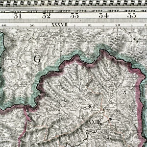
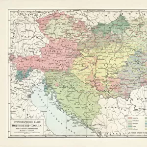
Poster Print : Map of the Kingdom of Hungary, 1742 (hand coloured engraving)
")


![]()
Poster Prints from Fine Art Finder
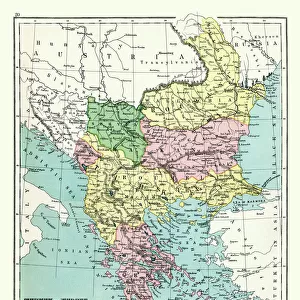
Map of the Kingdom of Hungary, 1742 (hand coloured engraving)
XCF306032 Map of the Kingdom of Hungary, 1742 (hand coloured engraving) by Mortier, Pierre (Pieter) (1661-1711) (after); 48x57 cm; Private Collection; French, out of copyright
Media ID 18254907
© Private Collection / Bridgeman Images
Balkans Bosnia Bulgaria Cartouche Countries Croatia Eastern Europe Eastern European Magyar Mapping Moldavia Romania Serbia Slovakia States Transylvania Transilvania
A3 (42 x 29.7cm) Poster Print
Discover the rich history of the Kingdom of Hungary with our stunning hand-coloured engraving print from Media Storehouse. This beautiful piece, titled "Map of the Kingdom of Hungary, 1742," is a masterpiece by the renowned artist Mortier, Pierre (Pieter). This detailed and intricately designed map provides a captivating glimpse into the past, offering a unique and educational addition to any home or office space. The vibrant hand-colouring adds depth and character to this historical treasure, making it a true work of art. Experience the beauty and history of the Kingdom of Hungary with our authentic, high-quality print from Media Storehouse.
Premium quality poster prints are printed on luxurious semi-gloss satin 270 gsm paper. Our meticulously crafted poster prints offer an affordable option for decorating any space, making them ideal for living rooms, bedrooms, offices and beyond. To ensure your poster arrives in good condition, we roll and send them in strong mailing tubes.
Poster prints are budget friendly enlarged prints in standard poster paper sizes (A0, A1, A2, A3 etc). Whilst poster paper is sometimes thinner and less durable than our other paper types, they are still ok for framing and should last many years. Our Archival Quality Photo Prints and Fine Art Paper Prints are printed on higher quality paper and the choice of which largely depends on your budget.
Estimated Product Size is 42.6cm x 30.6cm (16.8" x 12")
These are individually made so all sizes are approximate
Artwork printed orientated as per the preview above, with landscape (horizontal) orientation to match the source image.
FEATURES IN THESE COLLECTIONS
> Europe
> Bosnia and Herzegovina
> Maps
> Europe
> Bulgaria
> Related Images
> Europe
> Croatia
> Related Images
EDITORS COMMENTS
This hand-coloured engraving, titled "Map of the Kingdom of Hungary, 1742" takes us on a journey back in time to explore the intricate details of Eastern Europe's historical landscape. Measuring 48x57 cm, this exquisite piece is part of a private collection and showcases the exceptional craftsmanship of Pierre Mortier (1661-1711), who created it based on an earlier work. The map offers a fascinating glimpse into the Hungarian Empire during its peak in the mid-18th century. With its vibrant colours and meticulous cartography, it reveals not only the boundaries and states within Hungary but also neighboring regions such as Transylvania, Moldavia, Bosnia, Croatia, Romania, Slovakia, Bulgaria, Serbia and more. One cannot help but be drawn to the beautifully adorned cartouche that adorns this print. Its ornate design adds an air of elegance to an already impressive artwork. This map serves as both a navigational tool for explorers and historians alike while also being a stunning decorative piece that captures the essence of Eastern European history. As we gaze upon this remarkable creation from centuries past – now made available through www. bridgemanimages. com – we are reminded of how maps have always been essential in understanding our world's ever-changing landscapes. Whether used for practical purposes or admired purely for their artistic value like this one here; they continue to connect us with our rich cultural heritage.
MADE IN AUSTRALIA
Safe Shipping with 30 Day Money Back Guarantee
FREE PERSONALISATION*
We are proud to offer a range of customisation features including Personalised Captions, Color Filters and Picture Zoom Tools
SECURE PAYMENTS
We happily accept a wide range of payment options so you can pay for the things you need in the way that is most convenient for you
* Options may vary by product and licensing agreement. Zoomed Pictures can be adjusted in the Cart.