Poster Print > Europe > United Kingdom > Northern Ireland > County Down > Newcastle
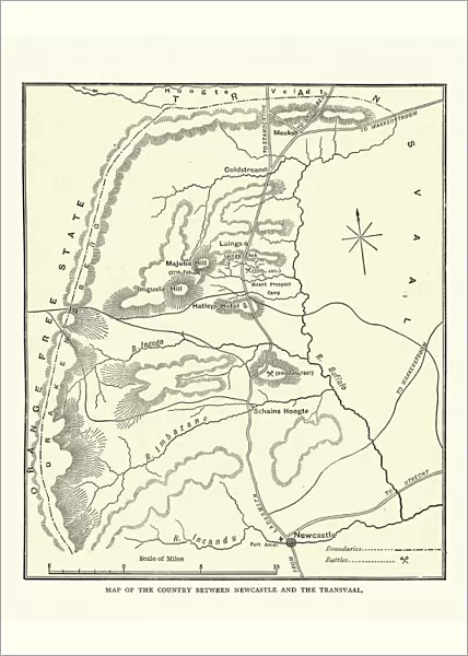
Poster Print : Map of the area between Newcastle and Transvaal South Africa


![]()
Poster Prints from Fine Art Storehouse
Map of the area between Newcastle and Transvaal South Africa
Vintage illustration Map of the area between Newcastle and Transvaal South Africa, during the First Boar War, 19th Century
Unleash your creativity and transform your space into a visual masterpiece!
duncan1890
Media ID 20327741
© of Duncan P Walker
A4 (29.7 x 21cm) Poster Print
Step back in time with our vintage illustration Map Print from the Media Storehouse collection. This exquisite reproduction, sourced from Fine Art Storehouse, showcases a captivating Map of the area between Newcastle and Transvaal South Africa during the First Boer War in the 19th Century. Created by the talented artist duncan1890, this timeless piece transports you back to an era of history filled with adventure and intrigue. Add this unique and intriguing Map Print to your home or office decor, and let the stories of the past come alive.
Premium quality poster prints are printed on luxurious semi-gloss satin 270 gsm paper. Our meticulously crafted poster prints offer an affordable option for decorating any space, making them ideal for living rooms, bedrooms, offices and beyond. To ensure your poster arrives in good condition, we roll and send them in strong mailing tubes.
Poster prints are budget friendly enlarged prints in standard poster paper sizes (A0, A1, A2, A3 etc). Whilst poster paper is sometimes thinner and less durable than our other paper types, they are still ok for framing and should last many years. Our Archival Quality Photo Prints and Fine Art Paper Prints are printed on higher quality paper and the choice of which largely depends on your budget.
Estimated Product Size is 21.6cm x 30.3cm (8.5" x 11.9")
These are individually made so all sizes are approximate
Artwork printed orientated as per the preview above, with portrait (vertical) orientation to match the source image.
FEATURES IN THESE COLLECTIONS
> Fine Art Storehouse
> History
> Battles & Wars
> Historcal Battle Maps and Plans
> Africa
> Related Images
> Africa
> South Africa
> Maps
> Africa
> South Africa
> Related Images
> Europe
> United Kingdom
> Northern Ireland
> County Down
> Newcastle
> Maps and Charts
> Related Images
EDITORS COMMENTS
This vintage illustration map takes us back to the 19th century, specifically during the First Boer War. The intricate details and historical significance of this print transport us to the area between Newcastle and Transvaal South Africa, offering a glimpse into a tumultuous period in history. As we gaze upon this piece, we are immediately struck by its rich colors and meticulous craftsmanship. Every line and contour on the map tells a story of conflict, exploration, and territorial disputes that defined this era. It serves as a visual time capsule, allowing us to understand how borders were drawn and contested during this pivotal moment in South African history. The Map of the area between Newcastle and Transvaal South Africa offers more than just geographical information; it provides insight into the political landscape of that time. It reminds us of the struggles faced by both sides during the First Boer War - British forces seeking control over valuable resources against determined Boer resistance fighting for their independence. Duncan1890's expertly preserved print captures not only an important chapter in history but also showcases his passion for preserving these significant moments through art. This artwork is not just an image; it is a gateway to understanding our past – reminding us that even amidst conflict, there is beauty in historical documentation.
MADE IN AUSTRALIA
Safe Shipping with 30 Day Money Back Guarantee
FREE PERSONALISATION*
We are proud to offer a range of customisation features including Personalised Captions, Color Filters and Picture Zoom Tools
SECURE PAYMENTS
We happily accept a wide range of payment options so you can pay for the things you need in the way that is most convenient for you
* Options may vary by product and licensing agreement. Zoomed Pictures can be adjusted in the Cart.