Poster Print > North America > Canada > Maps
Poster Print : Antique Map of Canada from the 16th to 18th Century


![]()
Poster Prints from Fine Art Storehouse
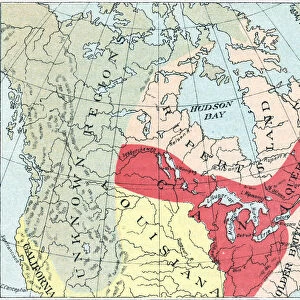
Antique Map of Canada from the 16th to 18th Century
Vintage map of Canada showing the early territorial boundaries of European Occupation. Vintage etching circa late 19th century
Unleash your creativity and transform your space into a visual masterpiece!
powerofforever
Media ID 15149727
© This content is subject to copyright
A4 (29.7 x 21cm) Poster Print
Step back in time with our Antique Map of Canada print from the Media Storehouse collection at Fine Art Storehouse. This captivating vintage map, created in the late 19th century, showcases the early territorial boundaries of European occupation in Canada during the 16th to 18th centuries. The intricate etching details bring history to life, transporting you back to an era of discovery and exploration. Add this beautiful piece to your home or office décor and let the story of Canada's rich history unfold.
Premium quality poster prints are printed on luxurious semi-gloss satin 270 gsm paper. Our meticulously crafted poster prints offer an affordable option for decorating any space, making them ideal for living rooms, bedrooms, offices and beyond. To ensure your poster arrives in good condition, we roll and send them in strong mailing tubes.
Poster prints are budget friendly enlarged prints in standard poster paper sizes (A0, A1, A2, A3 etc). Whilst poster paper is sometimes thinner and less durable than our other paper types, they are still ok for framing and should last many years. Our Archival Quality Photo Prints and Fine Art Paper Prints are printed on higher quality paper and the choice of which largely depends on your budget.
Estimated Product Size is 30.3cm x 21.6cm (11.9" x 8.5")
These are individually made so all sizes are approximate
Artwork printed orientated as per the preview above, with landscape (horizontal) or portrait (vertical) orientation to match the source image.
FEATURES IN THESE COLLECTIONS
> Fine Art Storehouse
> Map
> Historical Maps
> Europe
> Related Images
> Maps and Charts
> Early Maps
> Maps and Charts
> Related Images
> North America
> Canada
> Maps
> North America
> Canada
> Related Images
EDITORS COMMENTS
This print takes us on a journey back in time, immersing us in the rich history of Canada during the 16th to 18th centuries. The antique map displayed here offers a fascinating glimpse into the early territorial boundaries established by European powers as they embarked on their colonization of the Americas. With intricate details and exquisite craftsmanship, this vintage etching from the late 19th century transports us to an era when cartography was both an art form and a means of exploration. As we gaze upon this remarkable piece, our eyes are drawn to the distinct regions that once comprised Canada's landscape. From Acadia in the east to other territories shaped by European occupation, every line tells a story of conquest and cultural exchange. The map serves as a testament to how different nations sought control over vast lands, leaving behind indelible imprints that continue to shape Canada today. The powerofforever collection at Fine Art Storehouse has masterfully preserved this historical gem for all enthusiasts of geography and history alike. It reminds us not only of our past but also prompts reflection on how far we have come as a nation since those early days of exploration and settlement. With its timeless appeal and educational value, this print is sure to spark curiosity among admirers seeking glimpses into Canada's vibrant heritage. Whether displayed in classrooms or cherished within personal collections, it invites viewers on an immersive voyage through time – one that celebrates both human ingenuity and our ever-evolving understanding of our world's complex
MADE IN AUSTRALIA
Safe Shipping with 30 Day Money Back Guarantee
FREE PERSONALISATION*
We are proud to offer a range of customisation features including Personalised Captions, Color Filters and Picture Zoom Tools
SECURE PAYMENTS
We happily accept a wide range of payment options so you can pay for the things you need in the way that is most convenient for you
* Options may vary by product and licensing agreement. Zoomed Pictures can be adjusted in the Cart.