Poster Print > Arts > Landscape paintings > Waterfall and river artworks > River artworks
Poster Print : Antique Map of Niagara River Area during the War of 1812 - 19th Century


![]()
Poster Prints from Fine Art Storehouse
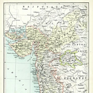
Antique Map of Niagara River Area during the War of 1812 - 19th Century
Vintage map showing early territorial borders and military positions in the Niagara River area during the War of 1812. Vintage etching circa late 19th century
Unleash your creativity and transform your space into a visual masterpiece!
powerofforever
Media ID 15149729
© This content is subject to copyright
A3 (42 x 29.7cm) Poster Print
Step back in time with our Antique Map of the Niagara River Area during the War of 1812 from Powerofforever at Media Storehouse. This captivating vintage print showcases intricate etching details of early territorial borders and military positions in the Niagara River area during the historic War of 1812. Transport yourself back to the 19th century with this authentic, late 1800s relic. Perfect for history enthusiasts, educators, or those seeking to add a touch of nostalgia to their home or office decor. Order now and let this antique map tell a story of a bygone era.
Premium quality poster prints are printed on luxurious semi-gloss satin 270 gsm paper. Our meticulously crafted poster prints offer an affordable option for decorating any space, making them ideal for living rooms, bedrooms, offices and beyond. To ensure your poster arrives in good condition, we roll and send them in strong mailing tubes.
Poster prints are budget friendly enlarged prints in standard poster paper sizes (A0, A1, A2, A3 etc). Whilst poster paper is sometimes thinner and less durable than our other paper types, they are still ok for framing and should last many years. Our Archival Quality Photo Prints and Fine Art Paper Prints are printed on higher quality paper and the choice of which largely depends on your budget.
Estimated Product Size is 42.6cm x 30.6cm (16.8" x 12")
These are individually made so all sizes are approximate
Artwork printed orientated as per the preview above, with landscape (horizontal) orientation to match the source image.
FEATURES IN THESE COLLECTIONS
> Fine Art Storehouse
> Map
> Historical Maps
> Arts
> Landscape paintings
> Waterfall and river artworks
> River artworks
> Maps and Charts
> Early Maps
> Maps and Charts
> Related Images
EDITORS COMMENTS
This antique map takes us back in time to the tumultuous era of the War of 1812. A true treasure for history enthusiasts, this vintage etching from the late 19th century offers a glimpse into the early territorial borders and military positions along the Niagara River area during this significant conflict. With intricate details and expert craftsmanship, this print showcases not only geographical features but also strategic fortifications such as Fort Schlosser that played a crucial role during those turbulent times. The map's faded hues and delicate lines evoke a sense of nostalgia, transporting us to an era long gone. As we study this remarkable piece, we can't help but imagine the soldiers who once stood on these very grounds, defending their territories with unwavering determination. It serves as a poignant reminder of the sacrifices made by countless individuals during one of America's defining moments. Whether you're an avid historian or simply appreciate artistry from bygone eras, this Antique Map of Niagara River Area during the War of 1812 is sure to captivate your imagination and spark conversations about our shared past. Display it proudly in your home or office as a testament to our collective heritage and an enduring symbol of resilience amidst adversity.
MADE IN AUSTRALIA
Safe Shipping with 30 Day Money Back Guarantee
FREE PERSONALISATION*
We are proud to offer a range of customisation features including Personalised Captions, Color Filters and Picture Zoom Tools
SECURE PAYMENTS
We happily accept a wide range of payment options so you can pay for the things you need in the way that is most convenient for you
* Options may vary by product and licensing agreement. Zoomed Pictures can be adjusted in the Cart.