Poster Print > Europe > France > Canton > Landes
Poster Print : Antique Map of North America at Canadas Confederation - 19th Century


![]()
Poster Prints from Fine Art Storehouse
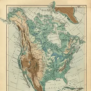
Antique Map of North America at Canadas Confederation - 19th Century
Vintage map of the territories of North America at Canadian Confederation in 1867. Vintage etching circa late 19th century
Unleash your creativity and transform your space into a visual masterpiece!
powerofforever
Media ID 15149709
© This content is subject to copyright
A4 (29.7 x 21cm) Poster Print
Step back in time with our Antique Map of North America at Canada's Confederation by powerofforever from the Media Storehouse Fine Art collection. This stunning vintage print showcases the territories of North America as they appeared during Canada's Confederation in 1867. Meticulously etched in the late 19th century, this antique map transports you back to an era of exploration and discovery. Add this beautiful work of art to your home or office to add a touch of historical charm and character.
Premium quality poster prints are printed on luxurious semi-gloss satin 270 gsm paper. Our meticulously crafted poster prints offer an affordable option for decorating any space, making them ideal for living rooms, bedrooms, offices and beyond. To ensure your poster arrives in good condition, we roll and send them in strong mailing tubes.
Poster prints are budget friendly enlarged prints in standard poster paper sizes (A0, A1, A2, A3 etc). Whilst poster paper is sometimes thinner and less durable than our other paper types, they are still ok for framing and should last many years. Our Archival Quality Photo Prints and Fine Art Paper Prints are printed on higher quality paper and the choice of which largely depends on your budget.
Estimated Product Size is 30.3cm x 21.6cm (11.9" x 8.5")
These are individually made so all sizes are approximate
Artwork printed orientated as per the preview above, with landscape (horizontal) orientation to match the source image.
FEATURES IN THESE COLLECTIONS
> Fine Art Storehouse
> Map
> Historical Maps
> Europe
> France
> Canton
> Landes
> Maps and Charts
> Related Images
> North America
> Canada
> Maps
> North America
> Canada
> Related Images
> North America
> Related Images
EDITORS COMMENTS
This print takes us back in time to the 19th century, offering a glimpse into the intricate details of an antique map. Titled "Antique Map of North America at Canada's Confederation" this vintage etching showcases the territories that comprised North America during the Canadian Confederation in 1867. The artist, powerofforever, has skillfully captured every contour and boundary line on this historical piece. As we delve into this mesmerizing artwork, our eyes are drawn to Ruppert's Land - a vast territory that once stretched across what is now known as Canada. The delicate lines and intricate markings depict not only geographical features but also hint at the political landscape of that era. Through this print, we can almost feel ourselves transported to a time when borders were being defined and nations were coming together. It serves as a reminder of how far we have come since then and how these early foundations shaped our present-day world. The attention to detail in this vintage map is truly remarkable; it invites us to explore each region with curiosity and wonder. Whether you're an avid history enthusiast or simply appreciate fine art, this exquisite print from Fine Art Storehouse will undoubtedly add depth and character to any space it graces.
MADE IN AUSTRALIA
Safe Shipping with 30 Day Money Back Guarantee
FREE PERSONALISATION*
We are proud to offer a range of customisation features including Personalised Captions, Color Filters and Picture Zoom Tools
SECURE PAYMENTS
We happily accept a wide range of payment options so you can pay for the things you need in the way that is most convenient for you
* Options may vary by product and licensing agreement. Zoomed Pictures can be adjusted in the Cart.