Poster Print > Maps and Charts > Africa
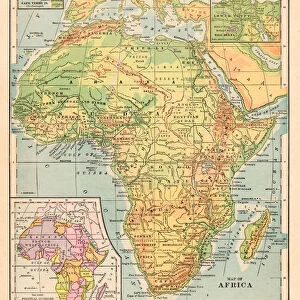
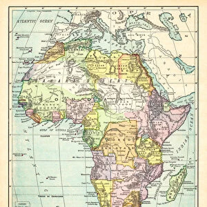
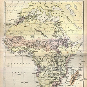
Poster Print : Map of Africa 1889


![]()
Poster Prints from Fine Art Storehouse
Map of Africa 1889
Comprehensive Geography by James Monteith - American Book Company 1882, 1889
Unleash your creativity and transform your space into a visual masterpiece!
THEPALMER
Media ID 18357281
A4 (29.7 x 21cm) Poster Print
Step back in time with our captivating Map of Africa 1889 print from the Media Storehouse collection. This exquisite piece, sourced from the comprehensive Geography book by James Monteith published by the American Book Company in 1889, features an intricately detailed illustration by THEPALMER. This vintage map offers a unique perspective into the historical geography of Africa during a pivotal period. Add this stunning print to your home or office to ignite conversations and inspire curiosity about the rich history of our world.
Premium quality poster prints are printed on luxurious semi-gloss satin 270 gsm paper. Our meticulously crafted poster prints offer an affordable option for decorating any space, making them ideal for living rooms, bedrooms, offices and beyond. To ensure your poster arrives in good condition, we roll and send them in strong mailing tubes.
Poster prints are budget friendly enlarged prints in standard poster paper sizes (A0, A1, A2, A3 etc). Whilst poster paper is sometimes thinner and less durable than our other paper types, they are still ok for framing and should last many years. Our Archival Quality Photo Prints and Fine Art Paper Prints are printed on higher quality paper and the choice of which largely depends on your budget.
Estimated Product Size is 21.6cm x 30.3cm (8.5" x 11.9")
These are individually made so all sizes are approximate
Artwork printed orientated as per the preview above, with portrait (vertical) orientation to match the source image.
FEATURES IN THESE COLLECTIONS
> Fine Art Storehouse
> Map
> Historical Maps
> Africa
> Related Images
> Maps and Charts
> Related Images
EDITORS COMMENTS
In this print titled "Map of Africa 1889" we are transported back in time to the late 19th century, when exploration and discovery were at their peak. The map, sourced from James Monteith's renowned Comprehensive Geography book published by the American Book Company in 1882 and updated in 1889, offers us a glimpse into the intricate details of Africa's diverse landscape. As our eyes wander across the aged parchment, we can't help but marvel at how much has changed since then. This vintage representation showcases a continent on the brink of transformation, with colonial powers vying for control over vast territories. It serves as a historical testament to an era marked by both curiosity and exploitation. The meticulous craftsmanship evident in every line and contour is a testament to Monteith's dedication as well as THEPALMER's skillful reproduction. The faded hues evoke nostalgia while adding an air of authenticity to this remarkable piece of cartographic history. This photograph print from Fine Art Storehouse allows us to appreciate not only the artistry behind such maps but also invites us to reflect upon Africa's complex past. It serves as a reminder that geography is not merely about borders or topography; it encapsulates stories of human endeavor, conquests, and cultural exchange. Whether displayed in homes or educational institutions, this timeless artwork sparks conversations about our shared heritage while honoring those who dedicated their lives to unraveling Africa's mysteries during an era long gone by.
MADE IN AUSTRALIA
Safe Shipping with 30 Day Money Back Guarantee
FREE PERSONALISATION*
We are proud to offer a range of customisation features including Personalised Captions, Color Filters and Picture Zoom Tools
SECURE PAYMENTS
We happily accept a wide range of payment options so you can pay for the things you need in the way that is most convenient for you
* Options may vary by product and licensing agreement. Zoomed Pictures can be adjusted in the Cart.