Poster Print > Arts > Artists > M > Mexican School Mexican School
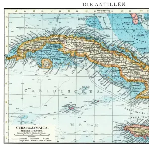
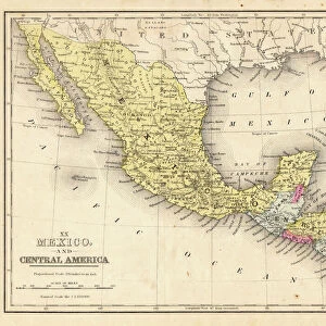
Poster Print : Map of Mexico and Central America 1871


![]()
Poster Prints from Fine Art Storehouse
Map of Mexico and Central America 1871
Colton and Fitchs Introductory School Geography - New York: Sheldon and Company 1871
Unleash your creativity and transform your space into a visual masterpiece!
THEPALMER
Media ID 15256733
© This content is subject to copyright
Caribbean Central America Cuba Dominican Republic Honduras Mexico Nicaragua Panama Puerto Rico West Indies
A4 (29.7 x 21cm) Poster Print
Step back in time with our vintage Map of Mexico and Central America print from ThePalmer's "Colton and Fitch's Introductory School Geography" published in 1871. This beautiful poster print, sourced from the Fine Art Storehouse, showcases intricate details of the geography of Mexico and Central America during an era of significant historical change. Add this captivating piece to your home or office to bring a touch of history and nostalgia to your space. Perfect for history enthusiasts, educators, or anyone with a love for vintage maps and geography.
Premium quality poster prints are printed on luxurious semi-gloss satin 270 gsm paper. Our meticulously crafted poster prints offer an affordable option for decorating any space, making them ideal for living rooms, bedrooms, offices and beyond. To ensure your poster arrives in good condition, we roll and send them in strong mailing tubes.
Poster prints are budget friendly enlarged prints in standard poster paper sizes (A0, A1, A2, A3 etc). Whilst poster paper is sometimes thinner and less durable than our other paper types, they are still ok for framing and should last many years. Our Archival Quality Photo Prints and Fine Art Paper Prints are printed on higher quality paper and the choice of which largely depends on your budget.
Estimated Product Size is 30.3cm x 21.6cm (11.9" x 8.5")
These are individually made so all sizes are approximate
Artwork printed orientated as per the preview above, with landscape (horizontal) or portrait (vertical) orientation to match the source image.
FEATURES IN THESE COLLECTIONS
> Fine Art Storehouse
> Map
> Historical Maps
> Arts
> Artists
> M
> Mexican School Mexican School
> Maps and Charts
> Related Images
> North America
> Cuba
> Maps
> North America
> Cuba
> Related Images
> North America
> Dominican Republic
> Maps
> North America
> Dominican Republic
> Related Images
> North America
> Honduras
> Maps
> North America
> Honduras
> Related Images
> North America
> Mexico
> Related Images
EDITORS COMMENTS
In this print titled "Map of Mexico and Central America 1871" we are transported back in time to the late 19th century. The map, originally featured in Colton and Fitch's Introductory School Geography, offers a fascinating glimpse into the geopolitical landscape of that era. With intricate details and vibrant colors, the map showcases not only Mexico and Central America but also other significant regions such as Cuba, Puerto Rico, and the West Indies. It provides a comprehensive overview of countries like Honduras, Nicaragua, Panama, and the Dominican Republic with their borders clearly delineated. The craftsmanship evident in this print is remarkable; it captures both historical accuracy and artistic beauty. The delicate lines tracing coastlines, rivers snaking through vast territories, and mountains majestically rising from the land evoke a sense of wonder about these distant lands. As we gaze upon this piece by THEPALMER from Fine Art Storehouse, we can't help but reflect on how much has changed since 1871. This snapshot freezes time for us to appreciate an era when cartography was still being explored as a means to understand our world better. Whether you're an avid history enthusiast or simply captivated by vintage maps' allure, this print serves as a reminder of our ever-evolving planet's rich past.
MADE IN AUSTRALIA
Safe Shipping with 30 Day Money Back Guarantee
FREE PERSONALISATION*
We are proud to offer a range of customisation features including Personalised Captions, Color Filters and Picture Zoom Tools
SECURE PAYMENTS
We happily accept a wide range of payment options so you can pay for the things you need in the way that is most convenient for you
* Options may vary by product and licensing agreement. Zoomed Pictures can be adjusted in the Cart.