Poster Print > Maps and Charts > Americas
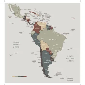
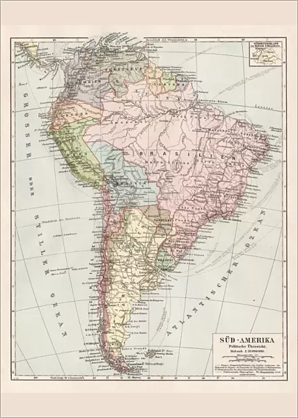
Poster Print : Map of South America 1900


![]()
Poster Prints from Fine Art Storehouse
Map of South America 1900
Meyers hand-Atlas Leipzig und Wien Verlag des Bibliographischen Instituts 1900
Unleash your creativity and transform your space into a visual masterpiece!
THEPALMER
Media ID 18106881
© 2014 Roberto Adrian Photography
A4 (29.7 x 21cm) Poster Print
Step back in time with our exquisite Map of South America 1900 by THEPALMER from the Media Storehouse Fine Art Storehouse collection. This stunning vintage poster print showcases intricate details from the Meyers Hand-Atlas published by the Bibliographisches Institut in Leipzig and Wien in 1900. Transport yourself back to a bygone era with this captivating and historically significant piece, perfect for adding a touch of nostalgia to any room in your home or office.
Premium quality poster prints are printed on luxurious semi-gloss satin 270 gsm paper. Our meticulously crafted poster prints offer an affordable option for decorating any space, making them ideal for living rooms, bedrooms, offices and beyond. To ensure your poster arrives in good condition, we roll and send them in strong mailing tubes.
Poster prints are budget friendly enlarged prints in standard poster paper sizes (A0, A1, A2, A3 etc). Whilst poster paper is sometimes thinner and less durable than our other paper types, they are still ok for framing and should last many years. Our Archival Quality Photo Prints and Fine Art Paper Prints are printed on higher quality paper and the choice of which largely depends on your budget.
Estimated Product Size is 21.6cm x 30.3cm (8.5" x 11.9")
These are individually made so all sizes are approximate
Artwork printed orientated as per the preview above, with portrait (vertical) orientation to match the source image.
FEATURES IN THESE COLLECTIONS
> Fine Art Storehouse
> Map
> Historical Maps
> South America
> Related Images
EDITORS COMMENTS
In this print titled "Map of South America 1900". THEPALMER takes us on a journey back in time to explore the rich history and geography of the continent. The map, sourced from Meyers hand-Atlas Leipzig und Wien Verlag des Bibliographischen Instituts in 1900, offers a fascinating glimpse into how South America was perceived over a century ago. The intricate details and vibrant colors of the map immediately draw our attention. From the towering peaks of the Andes to the lush Amazon rainforest, every feature is meticulously depicted, showcasing both natural wonders and human settlements. As we trace our fingers along its delicate lines, we can almost feel ourselves embarking on an adventure across this diverse land. Beyond its aesthetic appeal, this photograph print serves as a valuable historical artifact. It reminds us of an era when cartography played a crucial role in shaping our understanding of distant lands. The names of forgotten cities and territories evoke curiosity about their past significance or present-day existence. As we admire this piece from Fine Art Storehouse, let it transport us to another time – where explorers embarked on daring expeditions through uncharted territories and where imagination ran wild with tales of hidden treasures waiting to be discovered. Let it inspire us to appreciate not only the beauty but also the ever-changing nature of our world – reminding us that maps are not just static representations but living documents that reflect humanity's continuous quest for knowledge and exploration.
MADE IN AUSTRALIA
Safe Shipping with 30 Day Money Back Guarantee
FREE PERSONALISATION*
We are proud to offer a range of customisation features including Personalised Captions, Color Filters and Picture Zoom Tools
SECURE PAYMENTS
We happily accept a wide range of payment options so you can pay for the things you need in the way that is most convenient for you
* Options may vary by product and licensing agreement. Zoomed Pictures can be adjusted in the Cart.