Poster Print > Europe > Portugal > Maps
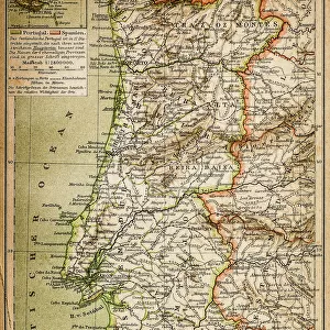
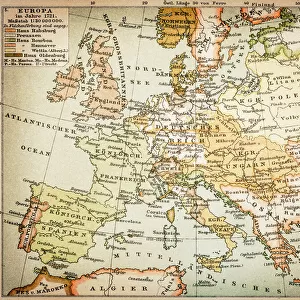
Poster Print : Spain and Portugal map 1895


![]()
Poster Prints from Fine Art Storehouse
Spain and Portugal map 1895
Meyers Konversations-Lexikon. Ein Nachschlagewerk des allgemeinen Wissens, 5th edition 17 volumes Bibliographisches Institut - Leipzig 1895-1897
Unleash your creativity and transform your space into a visual masterpiece!
THEPALMER
Media ID 13609325
© This content is subject to copyright
A4 (29.7 x 21cm) Poster Print
"Step back in time with our vintage Spain and Portugal Map print from ThePalmer's Meyers Konversations-Lexikon, 5th edition. This exquisite poster, published in 1895 by Bibliographisches Institut in Leipzig, adds a touch of history and elegance to any space. Explore the intricate details of Europe's Iberian Peninsula as it appeared over a century ago. Bring the rich history of Spain and Portugal into your home or office with this beautiful and authentic piece from our Media Storehouse Poster Prints collection."
Premium quality poster prints are printed on luxurious semi-gloss satin 270 gsm paper. Our meticulously crafted poster prints offer an affordable option for decorating any space, making them ideal for living rooms, bedrooms, offices and beyond. To ensure your poster arrives in good condition, we roll and send them in strong mailing tubes.
Poster prints are budget friendly enlarged prints in standard poster paper sizes (A0, A1, A2, A3 etc). Whilst poster paper is sometimes thinner and less durable than our other paper types, they are still ok for framing and should last many years. Our Archival Quality Photo Prints and Fine Art Paper Prints are printed on higher quality paper and the choice of which largely depends on your budget.
Estimated Product Size is 30.3cm x 21.6cm (11.9" x 8.5")
These are individually made so all sizes are approximate
Artwork printed orientated as per the preview above, with landscape (horizontal) orientation to match the source image.
FEATURES IN THESE COLLECTIONS
> Fine Art Storehouse
> Map
> Historical Maps
> Europe
> Portugal
> Related Images
> Europe
> Spain
> Related Images
> Maps and Charts
> Related Images
> Maps and Charts
> Spain
EDITORS COMMENTS
This print showcases a remarkable piece of history, the Spain and Portugal map from 1895. Taken from the renowned Meyers Konversations-Lexikon, this antique treasure offers a glimpse into the past with its intricate details and exquisite craftsmanship. The map, presented in a horizontal format, captures the physical geography of both countries during that era. Engraved and etched with precision, this illustration is a testament to the artistry of cartography in the late 19th century. The fine lines and delicate shading bring to life every contour of Spain's diverse landscapes and Portugal's coastal beauty. It serves as a visual time capsule, transporting us back to an era when exploration was at its peak. The aged appearance adds an air of authenticity to this vintage gem. Its weathered edges tell stories of countless hands tracing their fingers over its surface throughout generations. As we gaze upon it today, we are reminded of how far our understanding of these lands has come since then. "The Palmer" through Fine Art Storehouse, has skillfully captured this historical artifact for all to admire. This print allows us to appreciate not only the geographical accuracy but also the artistic mastery behind such maps from yesteryears. Whether you're an avid collector or simply fascinated by history, this enchanting piece will undoubtedly add depth and character to any space it graces
MADE IN AUSTRALIA
Safe Shipping with 30 Day Money Back Guarantee
FREE PERSONALISATION*
We are proud to offer a range of customisation features including Personalised Captions, Color Filters and Picture Zoom Tools
SECURE PAYMENTS
We happily accept a wide range of payment options so you can pay for the things you need in the way that is most convenient for you
* Options may vary by product and licensing agreement. Zoomed Pictures can be adjusted in the Cart.