Poster Print > Africa > Namibia > Maps
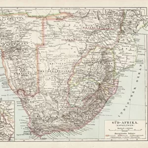
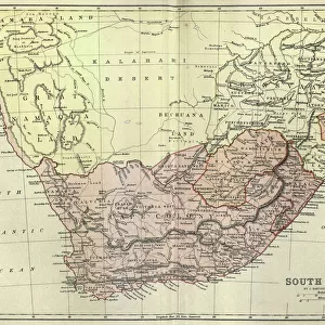
Poster Print : Topographic map of South Africa and Namibia, lithograph, published 1897


![]()
Poster Prints from Fine Art Storehouse
Topographic map of South Africa and Namibia, lithograph, published 1897
Topographic map of South Africa during the Dutch and British colonial era as well as Namibia (Deutsch-SAOEdwestafrika) during the German colonial era at the end of the 19th century. Lithograph, published in 1897
Unleash your creativity and transform your space into a visual masterpiece!
ZU_09
Media ID 18292305
A3 (42 x 29.7cm) Poster Print
Step back in time with our vintage Topographic Map of South Africa and Namibia print from the Media Storehouse Fine Art Storehouse. This beautiful lithograph, published in 1897, offers a fascinating glimpse into the colonial era of these two historic regions. Detailing the geography of South Africa during Dutch and British rule, as well as Namibia (Deutsch-Sudwestafrika) under German colonial rule, this map is a must-have for history enthusiasts and cartography collectors. With intricate lines and meticulous attention to detail, this print is not only a decorative addition to your home or office, but also a window into the past. Bring a piece of historical cartography into your space and transport yourself back in time with this unique and captivating print.
Premium quality poster prints are printed on luxurious semi-gloss satin 270 gsm paper. Our meticulously crafted poster prints offer an affordable option for decorating any space, making them ideal for living rooms, bedrooms, offices and beyond. To ensure your poster arrives in good condition, we roll and send them in strong mailing tubes.
Poster prints are budget friendly enlarged prints in standard poster paper sizes (A0, A1, A2, A3 etc). Whilst poster paper is sometimes thinner and less durable than our other paper types, they are still ok for framing and should last many years. Our Archival Quality Photo Prints and Fine Art Paper Prints are printed on higher quality paper and the choice of which largely depends on your budget.
Estimated Product Size is 42.6cm x 30.6cm (16.8" x 12")
These are individually made so all sizes are approximate
Artwork printed orientated as per the preview above, with landscape (horizontal) orientation to match the source image.
FEATURES IN THESE COLLECTIONS
> Fine Art Storehouse
> Map
> Historical Maps
> Africa
> Namibia
> Related Images
> Africa
> Related Images
> Africa
> South Africa
> Maps
> Africa
> South Africa
> Related Images
> Europe
> Germany
> Related Images
EDITORS COMMENTS
This lithograph, titled "Topographic map of South Africa and Namibia" takes us on a journey back in time to the late 19th century. Published in 1897, it offers a fascinating glimpse into the colonial era that shaped these two African nations. The intricate details and meticulous craftsmanship of this print are truly commendable. The map showcases South Africa during its Dutch and British colonial period, highlighting the geographical features that defined this region's landscape at the time. From majestic mountain ranges to winding rivers and sprawling plains, every contour is meticulously depicted with precision. Additionally, we are transported to Namibia (then known as Deutsch-SAOEdwestafrika), which was under German colonial rule during this period. This inclusion provides an invaluable historical context for understanding the complex dynamics that influenced both countries' development. As we delve deeper into this lithograph, it becomes evident that it not only serves as a navigational tool but also as a visual testament to the rich history of these lands. It invites us to reflect upon how political forces have shaped their landscapes over time. Overall, ZU_09's "Topographic map of South Africa and Namibia" is more than just an artistic creation; it is a window into our past—a reminder of how far we have come while acknowledging the legacies left behind by those who came before us.
MADE IN AUSTRALIA
Safe Shipping with 30 Day Money Back Guarantee
FREE PERSONALISATION*
We are proud to offer a range of customisation features including Personalised Captions, Color Filters and Picture Zoom Tools
SECURE PAYMENTS
We happily accept a wide range of payment options so you can pay for the things you need in the way that is most convenient for you
* Options may vary by product and licensing agreement. Zoomed Pictures can be adjusted in the Cart.