Poster Print > Europe > Related Images
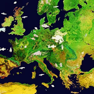
Poster Print : Satellite Map of Europe with Hurricane


![]()
Poster Prints from Fine Art Storehouse
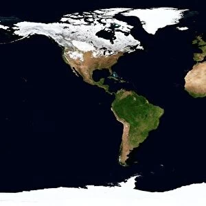
Satellite Map of Europe with Hurricane
SATELLITE MAP OF EUROPE WITH HURRICANE, Satellite Maps, 217403
Unleash your creativity and transform your space into a visual masterpiece!
GSO Images
Media ID 14833521
© This content is subject to copyright
A4 (29.7 x 21cm) Poster Print
"Discover the awe-inspiring power of nature with our Satellite Map of Europe with Hurricane print from GSO Images at Media Storehouse. This stunning fine art piece showcases a satellite image of Europe, where the tranquil continental landscape is dramatically disrupted by the towering form of a hurricane. The swirling storm system, with its dark clouds and powerful bands of rain and wind, adds an element of excitement and wonder to the familiar shape of Europe. This Satellite Map of Europe with Hurricane print is a captivating conversation starter and a beautiful addition to any room in your home or office. Order yours today from the Fine Art Storehouse at Media Storehouse."
Premium quality poster prints are printed on luxurious semi-gloss satin 270 gsm paper. Our meticulously crafted poster prints offer an affordable option for decorating any space, making them ideal for living rooms, bedrooms, offices and beyond. To ensure your poster arrives in good condition, we roll and send them in strong mailing tubes.
Poster prints are budget friendly enlarged prints in standard poster paper sizes (A0, A1, A2, A3 etc). Whilst poster paper is sometimes thinner and less durable than our other paper types, they are still ok for framing and should last many years. Our Archival Quality Photo Prints and Fine Art Paper Prints are printed on higher quality paper and the choice of which largely depends on your budget.
Estimated Image Size (if not cropped) is 20cm x 30.3cm (7.9" x 11.9")
Estimated Product Size is 21.6cm x 30.3cm (8.5" x 11.9")
These are individually made so all sizes are approximate
Artwork printed orientated as per the preview above, with portrait (vertical) orientation to match the source image.
FEATURES IN THESE COLLECTIONS
> Fine Art Storehouse
> Map
> Satellite Maps
> Europe
> Related Images
> Maps and Charts
> Related Images
EDITORS COMMENTS
This print titled "Satellite Map of Europe with Hurricane" takes us on a mesmerizing journey above the European continent, showcasing the intricate beauty and power of nature. The image captures a satellite's view of Europe, revealing its diverse landscapes, cities, and coastlines. However, what truly steals the spotlight is an awe-inspiring hurricane swirling over a portion of this vast region. The hurricane's presence creates a stark contrast against the otherwise serene backdrop. Its spiral shape dominates the frame as it unleashes its might upon land and sea alike. The vibrant colors used in this artwork further enhance our perception of this natural phenomenon; shades of deep blues and grays evoke feelings of both awe and trepidation. Through this photograph, we are reminded that even amidst civilization's advancements, Mother Nature remains an unstoppable force capable of shaping our world in ways beyond human control. It serves as a humbling reminder that despite our progress, we are still subject to her whims. This fine art print by GSO Images not only showcases their exceptional talent for capturing breathtaking scenes but also invites viewers to reflect on humanity's place within nature's grand design. Whether displayed in homes or offices, this piece will undoubtedly spark conversations about climate change, resilience, and mankind's relationship with the environment – making it an ideal addition to any art collection seeking to inspire contemplation and awareness.
MADE IN AUSTRALIA
Safe Shipping with 30 Day Money Back Guarantee
FREE PERSONALISATION*
We are proud to offer a range of customisation features including Personalised Captions, Color Filters and Picture Zoom Tools
SECURE PAYMENTS
We happily accept a wide range of payment options so you can pay for the things you need in the way that is most convenient for you
* Options may vary by product and licensing agreement. Zoomed Pictures can be adjusted in the Cart.