mail_outline sales@mediastorehouse.com
Framed Print
Canvas Print
Metal Print
Photographic Print
Poster Print
Fine Art Print
Jigsaw Puzzle
Photo Mug
Greetings Card
Cushion
Mouse Mat
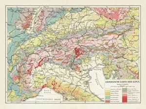
Geological map of the European Alps, lithograph, published in 1897Geological map of the European Alps. Lithograph, published in 1897
Venice. Creator: Brugnoli, Emanuele (1859-1944)Venice. Found in the Collection of the Museo Ottocento Bologna
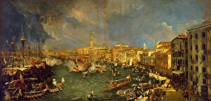
The departure of the Bucintoro, 1729. Creator: Stom, Antonio (1688-1734)The departure of the Bucintoro, 1729. Found in the Collection of the Fondazione Querini Stampalia
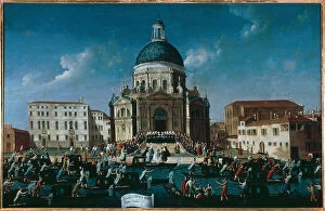
The wedding of a noble lady in Santa Maria della Salute, 1779-1792. Creator: Bella, Gabriele (1730-1799)The wedding of a noble lady in Santa Maria della Salute, 1779-1792. Found in the Collection of the Fondazione Querini Stampalia
The Doge's coronation on the Scala dei Giganti in the courtyard of the Doge's Palace, 1779-1792. Found in the Collection of the Fondazione Querini Stampalia
Le Champ de Bataille de L'Italie; mouvement des operations Italiennes jusqu'a la fin... 1917. Creator: UnknownLe Champ de Bataille de L'Italie; mouvement des operations Italiennes jusqu'a la fin de l'annee 1917, 1917. First World War
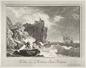
Second View of the Gulf of Venice, ca. 1770-1800. Creator: Francois Anne DavidSecond View of the Gulf of Venice, ca. 1770-1800
The Great Bridge, Chioggia, Gulf of Venice (engraving)962133 The Great Bridge, Chioggia, Gulf of Venice (engraving) by English School, (19th century); Private Collection; (add.info.: The Great Bridge, Chioggia, Gulf of Venice)
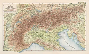
Topographic map of the European Alps, lithograph, published in 1897Topographic map of the European Alps. Lithograph, published in 1897
Satellite view of Italy and the Adriatic SeaNovember 17, 2004 - Satellite view of Italy and the Adriatic Sea. The waters along the Italian coastline are a milky green where the wind-tossed waves have churned the water
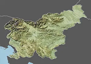
Slovenia, Relief Map with Border and MaskRelief map of Slovenia (with border and mask). This image was compiled from data acquired by landsat 5 & 7 satellites combined with elevation data