Poster Print > Granger Art on Demand > 20th Century Wars
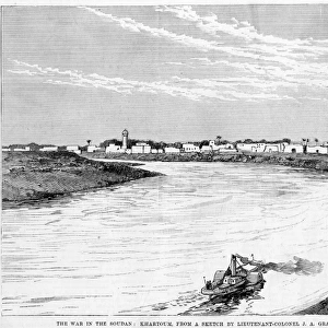
Poster Print : WORLD WAR I: MAP, C1919. Former German territories taken under the terms of the


![]()
Poster Prints from Granger
WORLD WAR I: MAP, C1919. Former German territories taken under the terms of the
WORLD WAR I: MAP, C1919.
Former German territories taken under the terms of the Treaty of Versailles. Map, c1919
Granger holds millions of images spanning more than 25,000 years of world history, from before the Stone Age to the dawn of the Space Age
Media ID 12406610
1919 Africa Congo East Africa Egypt Germany Indian Ocean Sudan Territory Treaty Of Versailles West Africa World War I
A3 (42 x 29.7cm) Poster Print
Step back in time with our vintage WORLD WAR I: MAP, C1919 print from the Media Storehouse collection at Granger Art on Demand. This historical poster showcases the former German territories taken under the terms of the Treaty of Versailles, providing a captivating glimpse into the geopolitical shifts of the early 20th century. Bring a piece of history into your home or office with this intriguing and informative poster print.
Premium quality poster prints are printed on luxurious semi-gloss satin 270 gsm paper. Our meticulously crafted poster prints offer an affordable option for decorating any space, making them ideal for living rooms, bedrooms, offices and beyond. To ensure your poster arrives in good condition, we roll and send them in strong mailing tubes.
Poster prints are budget friendly enlarged prints in standard poster paper sizes (A0, A1, A2, A3 etc). Whilst poster paper is sometimes thinner and less durable than our other paper types, they are still ok for framing and should last many years. Our Archival Quality Photo Prints and Fine Art Paper Prints are printed on higher quality paper and the choice of which largely depends on your budget.
Estimated Product Size is 30.6cm x 42.6cm (12" x 16.8")
These are individually made so all sizes are approximate
Artwork printed orientated as per the preview above, with portrait (vertical) orientation to match the source image.
EDITORS COMMENTS
This print showcases a historically significant map from the aftermath of World War I. Dating back to 1919, this meticulously detailed map highlights the former German territories that were taken under the terms of the Treaty of Versailles. The consequences of this treaty reverberated across continents and reshaped global dynamics. The map encompasses various regions, including Africa, Congo, East Africa, Egypt, Indian Ocean, Sudan, West Africa, and more. Each territory is marked with precision and clarity, providing a visual representation of the vast extent of German influence prior to their defeat in World War I. As we delve into this image's historical context further, it becomes evident that this map holds immense significance beyond its aesthetic appeal. It serves as a reminder of how political decisions made during times of conflict can have far-reaching consequences for nations and societies around the world. Whether you are an avid history enthusiast or simply intrigued by cartography's ability to convey complex narratives visually, this print offers a unique glimpse into an era defined by geopolitical transformations. Displaying it proudly in your home or office will not only spark conversations but also serve as a constant reminder of humanity's capacity for change and resilience in the face of adversity.
MADE IN AUSTRALIA
Safe Shipping with 30 Day Money Back Guarantee
FREE PERSONALISATION*
We are proud to offer a range of customisation features including Personalised Captions, Color Filters and Picture Zoom Tools
FREE COLORIZATION SERVICE
You can choose advanced AI Colorization for this picture at no extra charge!
SECURE PAYMENTS
We happily accept a wide range of payment options so you can pay for the things you need in the way that is most convenient for you
* Options may vary by product and licensing agreement. Zoomed Pictures can be adjusted in the Cart.