Poster Print > Maps and Charts > Related Images
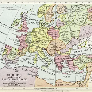
Poster Print : Map of Europe showing how it appeared after the Peace of Westphalia 1648AD


![]()
Poster Prints from MapSeeker
Map of Europe showing how it appeared after the Peace of Westphalia 1648AD
EHIST009
Welcome to the Mapseeker Image library and enter an historic gateway to one of the largest on-line collections of Historic Maps, Nostalgic Views, Vista's and Panorama's from a World gone by.
Media ID 20348258
Europe Europe Map Map Of Europe
A3 (42 x 29.7cm) Poster Print
Discover history with our exquisite Map of Europe print from the Media Storehouse collection, brought to you by MapSeeker (EHIST009). This detailed and captivating poster showcases Europe as it emerged after the signing of the Peace of Westphalia in 1648AD. Travel back in time and immerse yourself in the rich historical context of this pivotal moment. Ideal for history enthusiasts, classrooms, or any space in need of a thought-provoking conversation starter. Embrace the past and add this stunning piece to your decor today!
Premium quality poster prints are printed on luxurious semi-gloss satin 270 gsm paper. Our meticulously crafted poster prints offer an affordable option for decorating any space, making them ideal for living rooms, bedrooms, offices and beyond. To ensure your poster arrives in good condition, we roll and send them in strong mailing tubes.
Poster prints are budget friendly enlarged prints in standard poster paper sizes (A0, A1, A2, A3 etc). Whilst poster paper is sometimes thinner and less durable than our other paper types, they are still ok for framing and should last many years. Our Archival Quality Photo Prints and Fine Art Paper Prints are printed on higher quality paper and the choice of which largely depends on your budget.
Estimated Product Size is 42.6cm x 30.6cm (16.8" x 12")
These are individually made so all sizes are approximate
Artwork printed orientated as per the preview above, with landscape (horizontal) orientation to match the source image.
FEATURES IN THESE COLLECTIONS
> MapSeeker
> Maps of Europe
> Old Maps of Europe and Small Islands of
> Maps and Charts
> Related Images
EDITORS COMMENTS
This print showcases a historical treasure, the "Map of Europe showing how it appeared after the Peace of Westphalia in 1648 AD". A true testament to the transformative power of diplomacy, this map encapsulates a pivotal moment in European history. The Peace of Westphalia marked the end of the devastating Thirty Years' War, which had ravaged Europe for nearly three decades. This meticulously detailed map depicts the territorial boundaries and political landscape that emerged as a result of this landmark peace treaty. It offers an intriguing glimpse into a continent reshaped by negotiations and compromise. As we examine this map, we are transported back to an era when nations were grappling with complex religious conflicts and competing ambitions. The intricate cartography reveals not only borders but also cultural nuances and regional identities that have shaped Europe's rich tapestry. Beyond its historical significance, this print is a visual feast for geography enthusiasts and art lovers alike. Its vibrant colors bring life to each country's distinct shape while capturing our imagination with every contour and coastline. Whether displayed in classrooms or private collections, this MapSeeker photograph invites us to explore Europe's past through its geographical evolution post-Westphalian peace. It serves as both an educational tool and a stunning piece of artwork that sparks curiosity about our shared heritage
MADE IN AUSTRALIA
Safe Shipping with 30 Day Money Back Guarantee
FREE PERSONALISATION*
We are proud to offer a range of customisation features including Personalised Captions, Color Filters and Picture Zoom Tools
SECURE PAYMENTS
We happily accept a wide range of payment options so you can pay for the things you need in the way that is most convenient for you
* Options may vary by product and licensing agreement. Zoomed Pictures can be adjusted in the Cart.