Poster Print > Arts > Artists > C > Samuel de Champlain
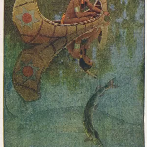
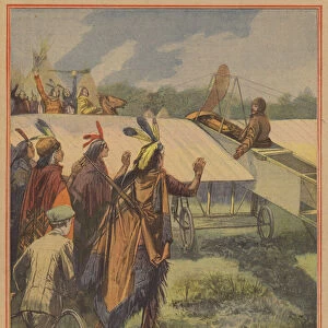
Poster Print : Champlain / Huron Indians


![]()
Poster Prints from Mary Evans Picture Library
Champlain / Huron Indians
Samuel De Champlain, with help from the recently befriended Huron Indians, on the war path with the Iroquois
Mary Evans Picture Library makes available wonderful images created for people to enjoy over the centuries
Media ID 4328849
© Mary Evans Picture Library 2015 - https://copyrighthub.org/s0/hub1/creation/maryevans/MaryEvansPictureID/10172587
1609 Befriended Champlain Huron Indians Iroquois Path Recently Samuel
A4 (29.7 x 21cm) Poster Print
"Introducing the Champlain/Huron Indians poster print from Media Storehouse's exclusive collection, brought to you in partnership with Mary Evans Prints Online. This captivating image captures the historic moment when explorer Samuel de Champlain, accompanied by Huron Indians, embarked on a war campaign against their Iroquois adversaries. A powerful reminder of the complex alliances and conflicts that shaped the early history of North America, this poster print is an essential addition to any classroom, office, or home decor. With its rich, vibrant colors and intricate detail, this print is sure to be a conversation starter and a source of inspiration for generations to come."
Premium quality poster prints are printed on luxurious semi-gloss satin 270 gsm paper. Our meticulously crafted poster prints offer an affordable option for decorating any space, making them ideal for living rooms, bedrooms, offices and beyond. To ensure your poster arrives in good condition, we roll and send them in strong mailing tubes.
Poster prints are budget friendly enlarged prints in standard poster paper sizes (A0, A1, A2, A3 etc). Whilst poster paper is sometimes thinner and less durable than our other paper types, they are still ok for framing and should last many years. Our Archival Quality Photo Prints and Fine Art Paper Prints are printed on higher quality paper and the choice of which largely depends on your budget.
Estimated Image Size (if not cropped) is 30.3cm x 19.4cm (11.9" x 7.6")
Estimated Product Size is 30.3cm x 21.6cm (11.9" x 8.5")
These are individually made so all sizes are approximate
Artwork printed orientated as per the preview above, with landscape (horizontal) orientation to match the source image.
FEATURES IN THESE COLLECTIONS
> Arts
> Artists
> C
> Samuel de Champlain
> North America
> Canada
> Related Images
EDITORS COMMENTS
In this evocative image from the annals of Canadian history, renowned explorer Samuel de Champlain (1567-1635) is depicted leading a war party of Huron Indians against their longstanding adversaries, the Iroquois, in the year 1609. Champlain, a Frenchman, had recently befriended the Huron people, who had welcomed him into their community and shared their knowledge of the land and its resources. The path before them winds through the dense forest, the trees casting long shadows as the sun begins to set. Champlain, dressed in his fur-trimmed explorer's coat, raises his hand in a gesture of encouragement to his Huron allies, who follow closely behind, their faces painted with the markings of war. The Iroquois, a formidable enemy, were known for their military prowess and had long been a threat to the Huron people. This historical event marked a significant moment in the relationship between the Europeans and the indigenous peoples of North America. Champlain's ability to forge alliances with the Huron and other native tribes was crucial to the success of French colonization in the region that would later become Canada. The image serves as a poignant reminder of the complex and often tumultuous history of interactions between European explorers and the indigenous peoples they encountered. The Huron-Iroquois War, as it came to be known, lasted for several years and resulted in significant losses for both sides. However, Champlain's alliance with the Huron proved to be a turning point in the conflict, ultimately leading to the weakening of Iroquois power in the region. This photograph, with its rich historical significance, offers a glimpse into the past and the intricate web of relationships that shaped the history of Canada.
MADE IN AUSTRALIA
Safe Shipping with 30 Day Money Back Guarantee
FREE PERSONALISATION*
We are proud to offer a range of customisation features including Personalised Captions, Color Filters and Picture Zoom Tools
SECURE PAYMENTS
We happily accept a wide range of payment options so you can pay for the things you need in the way that is most convenient for you
* Options may vary by product and licensing agreement. Zoomed Pictures can be adjusted in the Cart.