Poster Print > Europe > United Kingdom > Scotland > Maps
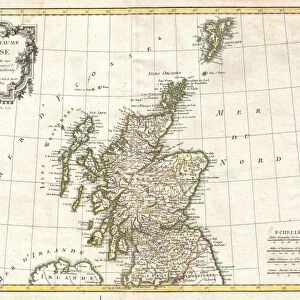
Poster Print : Map / Britain / Scotland


![]()
Poster Prints from Mary Evans Picture Library
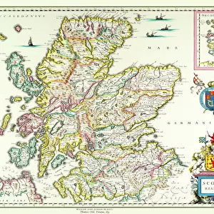
Map / Britain / Scotland
A map of Scotland
1817
Mary Evans Picture Library makes available wonderful images created for people to enjoy over the centuries
Media ID 8190541
© Mary Evans Picture Library 2015 - https://copyrighthub.org/s0/hub1/creation/maryevans/MaryEvansPictureID/10013049
A4 (29.7 x 21cm) Poster Print
Introducing the captivating "Map / Britain / Scotland" print from the Media Storehouse collection, brought to you by Mary Evans Picture Library from Mary Evans Prints Online. This stunning poster transports you back in time with an intricately detailed map of Scotland, as it appeared in 1817. Delve into the rich history of this enchanting land with this exquisite piece of art. The vintage map design is not only a beautiful addition to any room, but also a fascinating conversation starter. Bring a piece of the past into your present with the "Map / Britain / Scotland" print from Media Storehouse.
Premium quality poster prints are printed on luxurious semi-gloss satin 270 gsm paper. Our meticulously crafted poster prints offer an affordable option for decorating any space, making them ideal for living rooms, bedrooms, offices and beyond. To ensure your poster arrives in good condition, we roll and send them in strong mailing tubes.
Poster prints are budget friendly enlarged prints in standard poster paper sizes (A0, A1, A2, A3 etc). Whilst poster paper is sometimes thinner and less durable than our other paper types, they are still ok for framing and should last many years. Our Archival Quality Photo Prints and Fine Art Paper Prints are printed on higher quality paper and the choice of which largely depends on your budget.
Estimated Product Size is 21.6cm x 30.3cm (8.5" x 11.9")
These are individually made so all sizes are approximate
Artwork printed orientated as per the preview above, with portrait (vertical) orientation to match the source image.
FEATURES IN THESE COLLECTIONS
> Europe
> France
> Canton
> Landes
> Europe
> United Kingdom
> Scotland
> Maps
> Europe
> United Kingdom
> Scotland
> Posters
> Europe
> United Kingdom
> Scotland
> Related Images
> Maps and Charts
> Related Images
EDITORS COMMENTS
1. Title: A Glimpse into Scotland's Past: An 1817 Map Reveals Historical Boundaries and Territories This antique map print, hailing from the Mary Evans Picture Library, offers a fascinating glimpse into Scotland's rich history. Dated 1817, this map provides an intriguing look at the geographical layout of Scotland during that era. The map, titled "A New Map of Scotland," meticulously depicts the various counties, islands, and territories that comprised Scotland at the time. The intricate detailing of the map is a testament to the cartographic skills of the period, with each boundary and topographical feature rendered with precision. The map not only serves as a valuable historical document, but it also offers a visual representation of Scotland's complex political landscape during the early 19th century. The division of territories, the placement of major cities, and the depiction of various natural features all contribute to a captivating visual narrative of Scotland's past. One cannot help but be drawn to the intricate detailing of the map, with its carefully drawn borders, topographical features, and annotations. The map's antique charm is further accentuated by its aged appearance, with the paper showing signs of wear and the ink displaying subtle variations in tone and hue. This map print is an essential addition to any collection focusing on Scottish history, cartography, or antique maps. It offers a unique perspective into Scotland's past, allowing us to explore the historical context and geographical layout of a time long gone. Whether used for educational purposes, personal enjoyment, or as a conversation starter, this 1817 map of Scotland is sure to inspire curiosity and fascination.
MADE IN AUSTRALIA
Safe Shipping with 30 Day Money Back Guarantee
FREE PERSONALISATION*
We are proud to offer a range of customisation features including Personalised Captions, Color Filters and Picture Zoom Tools
SECURE PAYMENTS
We happily accept a wide range of payment options so you can pay for the things you need in the way that is most convenient for you
* Options may vary by product and licensing agreement. Zoomed Pictures can be adjusted in the Cart.