Poster Print > Asia > Malaysia > Maps
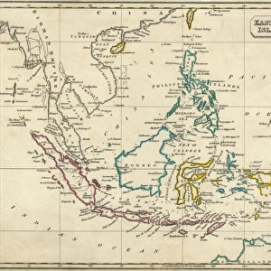
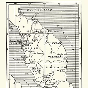
Poster Print : Map of Malaysia 1908


![]()
Poster Prints from Mary Evans Picture Library
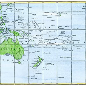
Map of Malaysia 1908
A map showing all the islands that make up Malaysia Date: 1908
Mary Evans Picture Library makes available wonderful images created for people to enjoy over the centuries
Media ID 7154381
© Mary Evans Picture Library 2015 - https://copyrighthub.org/s0/hub1/creation/maryevans/MaryEvansPictureID/10149907
Borneo Guinea Java Malaysia Maps Philippines Sumatra
A4 (29.7 x 21cm) Poster Print
"Discover the rich history of Malaysia with our exquisite Map of Malaysia 1908 print from Media Storehouse. This vintage map, sourced from Mary Evans Prints Online, showcases the islands that make up Malaysia as they appeared in 1908. A beautiful addition to any home or office, this rights-managed print transports you back in time, making it an ideal gift for history enthusiasts, geography buffs, or anyone with a fondness for the past. Bring a piece of Malaysia's fascinating history into your space and ignite intriguing conversations with this stunning and authentic poster print."
Premium quality poster prints are printed on luxurious semi-gloss satin 270 gsm paper. Our meticulously crafted poster prints offer an affordable option for decorating any space, making them ideal for living rooms, bedrooms, offices and beyond. To ensure your poster arrives in good condition, we roll and send them in strong mailing tubes.
Poster prints are budget friendly enlarged prints in standard poster paper sizes (A0, A1, A2, A3 etc). Whilst poster paper is sometimes thinner and less durable than our other paper types, they are still ok for framing and should last many years. Our Archival Quality Photo Prints and Fine Art Paper Prints are printed on higher quality paper and the choice of which largely depends on your budget.
Estimated Image Size (if not cropped) is 30.3cm x 19cm (11.9" x 7.5")
Estimated Product Size is 30.3cm x 21.6cm (11.9" x 8.5")
These are individually made so all sizes are approximate
Artwork printed orientated as per the preview above, with landscape (horizontal) orientation to match the source image.
FEATURES IN THESE COLLECTIONS
> Asia
> Malaysia
> Related Images
> Asia
> Philippines
> Maps
> Asia
> Philippines
> Related Images
> Asia
> Related Images
> Maps and Charts
> Related Images
EDITORS COMMENTS
1. Title: "A Vintage Glimpse of Malaysia and Its Surrounding Islands: A 1908 Map Revealing the Extent of British Colonial Influence" This vintage map print, dated 1908, offers a fascinating glimpse into the geography and colonial history of Malaysia and its surrounding islands. The map, titled "Malay Peninsula and Surrounding Islands," showcases the intricate detail of the region during a pivotal period in its history. The map, produced in 1908, depicts the Malay Peninsula, Sumatra, Java, the Philippines, Borneo, New Guinea, and other islands in the region. The British colonial influence is evident, as the map highlights the administrative boundaries of various British territories, including the Straits Settlements and the Federated Malay States. The map's intricate detail extends to the depiction of numerous islands, including the Riau Archipelago, the Andaman and Nicobar Islands, and the Sulu Archipelago. The map also includes annotations indicating major cities, rivers, and other topographical features. At the time, the British had established significant colonial holdings in the region, with Penang, Singapore, and Melaka being prominent British territories. The map reflects the extent of British influence, which extended beyond the Malay Peninsula to include territories in Sumatra, Borneo, and the eastern half of New Guinea. This map print is an essential addition to any collection focusing on Malaysian history, colonialism, or cartography. Its intricate detail and historical significance make it an engaging and educational piece for both personal and academic use. The map's antique charm and historical accuracy transport us back to a time when the world was being explored and mapped with newfound precision. This map print invites us to delve deeper into the rich history of Malaysia and its surrounding islands.
MADE IN AUSTRALIA
Safe Shipping with 30 Day Money Back Guarantee
FREE PERSONALISATION*
We are proud to offer a range of customisation features including Personalised Captions, Color Filters and Picture Zoom Tools
SECURE PAYMENTS
We happily accept a wide range of payment options so you can pay for the things you need in the way that is most convenient for you
* Options may vary by product and licensing agreement. Zoomed Pictures can be adjusted in the Cart.