Poster Print > Europe > Poland > Maps
Poster Print : Map / Europe / Poland 1772


![]()
Poster Prints from Mary Evans Picture Library
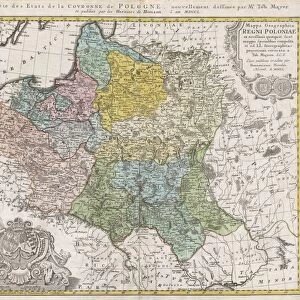
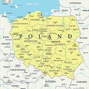
Map / Europe / Poland 1772
A German map of Poland and its neighbours in the late 18th century
Mary Evans Picture Library makes available wonderful images created for people to enjoy over the centuries
Media ID 594544
© Mary Evans Picture Library 2015 - https://copyrighthub.org/s0/hub1/creation/maryevans/MaryEvansPictureID/10046847
A4 (29.7 x 21cm) Poster Print
Introducing the captivating "Map / Europe / Poland 1772" print from the Media Storehouse collection, brought to you by Mary Evans Picture Library via Mary Evans Prints Online. This exquisite poster transports you back in time with a detailed and intricately designed map of Europe, focusing on Poland in the late 18th century. The map showcases the political landscape during the era of the Partitions of Poland, revealing the borders and territories of Poland and its neighboring countries. Bring history to life in your home or office with this beautiful and educational poster print.
Premium quality poster prints are printed on luxurious semi-gloss satin 270 gsm paper. Our meticulously crafted poster prints offer an affordable option for decorating any space, making them ideal for living rooms, bedrooms, offices and beyond. To ensure your poster arrives in good condition, we roll and send them in strong mailing tubes.
Poster prints are budget friendly enlarged prints in standard poster paper sizes (A0, A1, A2, A3 etc). Whilst poster paper is sometimes thinner and less durable than our other paper types, they are still ok for framing and should last many years. Our Archival Quality Photo Prints and Fine Art Paper Prints are printed on higher quality paper and the choice of which largely depends on your budget.
Estimated Product Size is 30.3cm x 21.6cm (11.9" x 8.5")
These are individually made so all sizes are approximate
Artwork printed orientated as per the preview above, with landscape (horizontal) orientation to match the source image.
FEATURES IN THESE COLLECTIONS
> Mary Evans Prints Online
> Maps
> Europe
> Germany
> Related Images
> Europe
> Poland
> Related Images
> Europe
> Related Images
> Maps and Charts
> Early Maps
EDITORS COMMENTS
This fascinating historical print from Mary Evans Picture Library showcases a German map of Poland and its neighboring countries in the late 18th century. The year is 1772, a time when Europe was undergoing significant political and territorial changes. This meticulously detailed map offers a glimpse into the complex geopolitical landscape of that era, with intricate borders and place names that reflect the shifting alliances and power struggles of the time.
As we study this map, we can see how Poland was situated among its neighbors, including Prussia, Austria, Russia, and others. Each region is clearly delineated with precision and accuracy, providing valuable insight into the boundaries and territories of these nations during this period.
The rich history captured in this print allows us to travel back in time and explore Europe as it existed over two centuries ago. It serves as a reminder of the ever-changing nature of politics and geography, highlighting how borders have shifted over time due to wars, treaties, and other factors.
For history enthusiasts or anyone interested in cartography, this German map of Poland from 1772 is sure to spark curiosity and fascination. It stands as a testament to the enduring importance of maps in understanding our past and navigating our present world.
MADE IN AUSTRALIA
Safe Shipping with 30 Day Money Back Guarantee
FREE PERSONALISATION*
We are proud to offer a range of customisation features including Personalised Captions, Color Filters and Picture Zoom Tools
SECURE PAYMENTS
We happily accept a wide range of payment options so you can pay for the things you need in the way that is most convenient for you
* Options may vary by product and licensing agreement. Zoomed Pictures can be adjusted in the Cart.