Poster Print > Maps and Charts > Americas
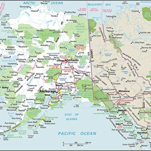
Poster Print : Alaska, US Coast Survey, America 1869 Date: 1869


![]()
Poster Prints from Mary Evans Picture Library
Alaska, US Coast Survey, America 1869 Date: 1869
Mary Evans Picture Library makes available wonderful images created for people to enjoy over the centuries
Media ID 7403207
© Mary Evans Picture Library 2015 - https://copyrighthub.org/s0/hub1/creation/maryevans/MaryEvansPictureID/10474880
A4 (29.7 x 21cm) Poster Print
"Discover the breathtaking beauty of Alaska with our exquisite poster prints from Media Storehouse. Featuring an iconic image from the US Coast Survey, America 1869, this captivating poster transport you to the untamed wilderness of America's last frontier. The intricate details of the snow-capped mountains, crystal-clear waters, and vast expanses of wilderness are brought to life in stunning high-definition detail. Our poster prints are sourced from Mary Evans Prints Online and come with a rights-managed license, ensuring the authenticity and quality of your artwork. Bring the wonders of Alaska into your home or office and let its enchanting allure inspire and captivate you every day."
Premium quality poster prints are printed on luxurious semi-gloss satin 270 gsm paper. Our meticulously crafted poster prints offer an affordable option for decorating any space, making them ideal for living rooms, bedrooms, offices and beyond. To ensure your poster arrives in good condition, we roll and send them in strong mailing tubes.
Poster prints are budget friendly enlarged prints in standard poster paper sizes (A0, A1, A2, A3 etc). Whilst poster paper is sometimes thinner and less durable than our other paper types, they are still ok for framing and should last many years. Our Archival Quality Photo Prints and Fine Art Paper Prints are printed on higher quality paper and the choice of which largely depends on your budget.
Estimated Product Size is 30.3cm x 21.6cm (11.9" x 8.5")
These are individually made so all sizes are approximate
Artwork printed orientated as per the preview above, with landscape (horizontal) or portrait (vertical) orientation to match the source image.
FEATURES IN THESE COLLECTIONS
> Mary Evans Prints Online
> National Archives
> Maps and Charts
> Related Images
EDITORS COMMENTS
This stunning 19th-century map print, titled "Alaska and Part of Adjacent Seas," is an intriguing glimpse into the exploration and cartographic history of Alaska during the United States' early foray into the region. Dated 1869, the map was produced by the United States Coast Survey, a branch of the U.S. Navy that was responsible for creating detailed charts and maps of the country's waters and coastlines. The map is a testament to the extensive geographical knowledge that had been gained during the 17th and 1800s, as European and American explorers ventured into the vast and largely uncharted territories of the North Pacific. The map's intricate detailing of the coastlines, islands, and waterways of Alaska and its neighboring regions reflects the painstaking efforts of surveyors and cartographers to accurately document this remote and challenging landscape. At the time, Alaska was still largely unexplored and uninhabited by Americans, and the map provides a fascinating snapshot of the geographical knowledge available to those who might have been considering a journey to the region. The map also includes annotations and labels denoting various geographical features, including mountains, rivers, and bays, as well as the names of some of the indigenous tribes that inhabited the area. The map's antique aesthetic, with its intricate detailing and elegant typography, adds to its historical and artistic value. It is a reminder of the rich cartographic history of the United States and the remarkable achievements of the explorers, surveyors, and cartographers who helped to map and document the country's vast and diverse landscape.
MADE IN AUSTRALIA
Safe Shipping with 30 Day Money Back Guarantee
FREE PERSONALISATION*
We are proud to offer a range of customisation features including Personalised Captions, Color Filters and Picture Zoom Tools
SECURE PAYMENTS
We happily accept a wide range of payment options so you can pay for the things you need in the way that is most convenient for you
* Options may vary by product and licensing agreement. Zoomed Pictures can be adjusted in the Cart.