Poster Print > Maps and Charts > British Empire Maps
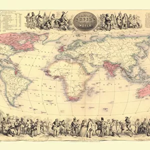
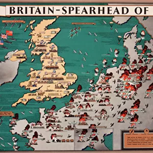
Poster Print : Empire map of the world


![]()
Poster Prints from Mary Evans Picture Library
Empire map of the world
Mary Evans Picture Library makes available wonderful images created for people to enjoy over the centuries
Media ID 7401367
© Mary Evans Picture Library 2015 - https://copyrighthub.org/s0/hub1/creation/maryevans/MaryEvansPictureID/10473914
A4 (29.7 x 21cm) Poster Print
"Discover the rich history of global empires with our stunning Empire Map of the World poster print from Media Storehouse. This captivating image, sourced from Mary Evans Prints Online, offers a fascinating glimpse into the territories and reach of historical empires. Bring history to life in your home or office with this beautifully detailed and intricately designed poster, a perfect addition to any room telling a story of the past. With high-quality printing, vibrant colors, and archival-quality materials, our poster prints are built to last, ensuring your investment is a long-lasting and timeless one. Elevate your space and ignite your curiosity with Media Storehouse's Empire Map of the World poster print."
Premium quality poster prints are printed on luxurious semi-gloss satin 270 gsm paper. Our meticulously crafted poster prints offer an affordable option for decorating any space, making them ideal for living rooms, bedrooms, offices and beyond. To ensure your poster arrives in good condition, we roll and send them in strong mailing tubes.
Poster prints are budget friendly enlarged prints in standard poster paper sizes (A0, A1, A2, A3 etc). Whilst poster paper is sometimes thinner and less durable than our other paper types, they are still ok for framing and should last many years. Our Archival Quality Photo Prints and Fine Art Paper Prints are printed on higher quality paper and the choice of which largely depends on your budget.
Estimated Image Size (if not cropped) is 30.3cm x 20cm (11.9" x 7.9")
Estimated Product Size is 30.3cm x 21.6cm (11.9" x 8.5")
These are individually made so all sizes are approximate
Artwork printed orientated as per the preview above, with landscape (horizontal) orientation to match the source image.
FEATURES IN THESE COLLECTIONS
> Mary Evans Prints Online
> National Archives
> Maps and Charts
> British Empire Maps
> Maps and Charts
> Related Images
> Maps and Charts
> World
EDITORS COMMENTS
Step back in time and explore the vast expanse of the British Empire in this and intricately detailed map print from the 1930s. This Empire map of the world, a stunning example of cartographic art from the interwar period, showcases the reach and influence of the British Empire at the height of its power. The map, with its rich, earthy tones and bold, clear lines, transports us back to an era of imperial grandeur and exploration. The intricate detailing of the map reveals the vast territories under British rule, from the far-flung colonies in the Caribbean and the Pacific to the dominions in Canada, Australia, and New Zealand. The map also highlights the strategic military bases and key ports of the British Empire, providing a glimpse into the naval and military might of the time. The map's design is both functional and aesthetically pleasing, making it an excellent addition to any home or office. This map is a testament to the historical significance of the British Empire during the 1920s and 1930s, a time of great political, economic, and cultural change. It offers a unique perspective on the world as it was then, and serves as a reminder of the rich and complex history that shapes our world today. Printed on high-quality paper, this map print is a must-have for history buffs, cartography enthusiasts, and anyone interested in the history of the British Empire. Hang it on your wall and let it inspire your imagination as you explore the stories and adventures that lie within its borders.
MADE IN AUSTRALIA
Safe Shipping with 30 Day Money Back Guarantee
FREE PERSONALISATION*
We are proud to offer a range of customisation features including Personalised Captions, Color Filters and Picture Zoom Tools
SECURE PAYMENTS
We happily accept a wide range of payment options so you can pay for the things you need in the way that is most convenient for you
* Options may vary by product and licensing agreement. Zoomed Pictures can be adjusted in the Cart.