Poster Print > Europe > Portugal > Maps
Poster Print : Map of Lisbon


![]()
Poster Prints from Mary Evans Picture Library
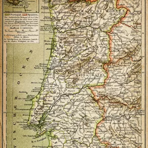
Map of Lisbon
Map of the city of Lisbon, Portugal 1871 Date: 1871
Mary Evans Picture Library makes available wonderful images created for people to enjoy over the centuries
Media ID 7403093
© Mary Evans Picture Library 2015 - https://copyrighthub.org/s0/hub1/creation/maryevans/MaryEvansPictureID/10474572
A1 (84.1 x 59.4cm) Poster Print
"Discover the rich history and charm of Lisbon, Portugal with our stunning Map of Lisbon poster print. Dated back to 1871, this exquisite map from Mary Evans Prints Online transports you back in time, revealing the city's layout and architectural gems as they once were. Bring a piece of European history into your home or office with this beautifully detailed and intricately designed poster print from Media Storehouse. Perfect for travel enthusiasts, history buffs, or anyone looking to add a touch of old-world elegance to their space."
Premium quality poster prints are printed on luxurious glossy or matte 270 gsm paper. Our meticulously crafted poster prints offer an affordable option for decorating any space, making them ideal for living rooms, bedrooms, offices and beyond. To ensure your poster arrives in good condition, we roll and send them in strong mailing tubes.
Poster prints are budget friendly enlarged prints in standard poster paper sizes (A0, A1, A2, A3 etc). Whilst poster paper is sometimes thinner and less durable than our other paper types, they are still ok for framing and should last many years. Our Archival Quality Photo Prints and Fine Art Paper Prints are printed on higher quality paper and the choice of which largely depends on your budget.
Estimated Image Size (if not cropped) is 84.6cm x 44cm (33.3" x 17.3")
Estimated Product Size is 84.6cm x 59.6cm (33.3" x 23.5")
These are individually made so all sizes are approximate
Artwork printed orientated as per the preview above, with landscape (horizontal) orientation to match the source image.
FEATURES IN THESE COLLECTIONS
> Mary Evans Prints Online
> National Archives
> Europe
> Portugal
> Related Images
> Maps and Charts
> Related Images
EDITORS COMMENTS
This stunning vintage print of the "Map of Lisbon, Portugal 1871" offers a fascinating glimpse into the intricate layout and architecture of the city during the 19th century. The detailed plan showcases the bustling streets, grand buildings, and charming neighborhoods that made up Lisbon at that time.
As you study this historical map, you can almost imagine yourself wandering through the narrow alleyways and vibrant squares of this enchanting city. Each street is carefully labeled, giving insight into the various districts and landmarks that defined Lisbon in 1871.
From iconic structures like churches and palaces to bustling marketplaces and tranquil parks, every corner of Lisbon is meticulously depicted on this map. It serves as a valuable resource for historians, urban planners, or anyone with an interest in exploring the rich history of Portugal's capital city.
Whether you have a personal connection to Lisbon or simply appreciate beautifully crafted cartography, this print is sure to spark your imagination and transport you back in time to a bygone era. Display it proudly in your home or office as a conversation piece that celebrates both artistry and history.
MADE IN AUSTRALIA
Safe Shipping with 30 Day Money Back Guarantee
FREE PERSONALISATION*
We are proud to offer a range of customisation features including Personalised Captions, Color Filters and Picture Zoom Tools
SECURE PAYMENTS
We happily accept a wide range of payment options so you can pay for the things you need in the way that is most convenient for you
* Options may vary by product and licensing agreement. Zoomed Pictures can be adjusted in the Cart.