Poster Print > Europe > United Kingdom > England > London > River Thames
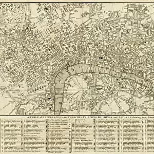
Poster Print : Map of London by John Rocque, 1745


![]()
Poster Prints from Mary Evans Picture Library
Map of London by John Rocque, 1745
Map of London by John Rocque, 1745.
1745
Mary Evans Picture Library makes available wonderful images created for people to enjoy over the centuries
Media ID 23101828
© Mary Evans Picture Library
1740s 1745 Capital Maps Rocque
A4 (29.7 x 21cm) Poster Print
Step back in time with our exquisite selection of antique Map of London prints from the Media Storehouse collection. This stunning reproduction, featuring the intricately detailed Map of London by John Rocque from 1745, sourced from the esteemed Mary Evans Picture Library, transports you to the 18th century. Each print is meticulously crafted to capture the essence of the original, allowing you to adorn your walls with a piece of historical artistry. Bring a touch of the past into your modern home or office.
Premium quality poster prints are printed on luxurious semi-gloss satin 270 gsm paper. Our meticulously crafted poster prints offer an affordable option for decorating any space, making them ideal for living rooms, bedrooms, offices and beyond. To ensure your poster arrives in good condition, we roll and send them in strong mailing tubes.
Poster prints are budget friendly enlarged prints in standard poster paper sizes (A0, A1, A2, A3 etc). Whilst poster paper is sometimes thinner and less durable than our other paper types, they are still ok for framing and should last many years. Our Archival Quality Photo Prints and Fine Art Paper Prints are printed on higher quality paper and the choice of which largely depends on your budget.
Estimated Image Size (if not cropped) is 30.3cm x 19.9cm (11.9" x 7.8")
Estimated Product Size is 30.3cm x 21.6cm (11.9" x 8.5")
These are individually made so all sizes are approximate
Artwork printed orientated as per the preview above, with landscape (horizontal) orientation to match the source image.
FEATURES IN THESE COLLECTIONS
> Mary Evans Prints Online
> New Images August 2021
> Arts
> Artists
> R
> John Rocque
> Arts
> Landscape paintings
> Waterfall and river artworks
> River artworks
> Europe
> United Kingdom
> England
> London
> Related Images
> Europe
> United Kingdom
> England
> London
> River Thames
> Maps and Charts
> Related Images
EDITORS COMMENTS
This stunning map print, titled "A New and Correct Map of the Cities of London and Westminster, and the Borough of Southwark," was created by renowned English cartographer John Rocque in 1745. The map offers a detailed and accurate representation of London during the 1740s, showcasing the city's intricate street layout, topography, and significant landmarks. The Thames River, a vital artery of London, runs through the heart of the map, with its winding path marked by the precise placement of bridges and wharves. The city's iconic buildings, such as St. Paul's Cathedral, Westminster Abbey, and the Tower of London, are clearly depicted, providing a glimpse into London's rich history. The map also highlights the city's diverse neighborhoods, including the fashionable areas of Mayfair and Covent Garden, as well as the bustling markets and industries of Smithfield and Billingsgate. The meticulous attention to detail is evident in the inclusion of parks, churches, schools, and even individual houses. John Rocque was a pioneer in the field of topographical mapping, using the most up-to-date information and surveying techniques to create accurate and visually appealing maps. This map of London, produced in 1745, is a testament to his skill and dedication. It offers a fascinating glimpse into the past, allowing us to explore the streets and landmarks of London as they appeared over 275 years ago.
MADE IN AUSTRALIA
Safe Shipping with 30 Day Money Back Guarantee
FREE PERSONALISATION*
We are proud to offer a range of customisation features including Personalised Captions, Color Filters and Picture Zoom Tools
SECURE PAYMENTS
We happily accept a wide range of payment options so you can pay for the things you need in the way that is most convenient for you
* Options may vary by product and licensing agreement. Zoomed Pictures can be adjusted in the Cart.