Poster Print > Africa > Madagascar > Maps
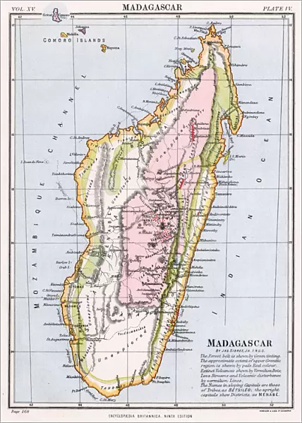
Poster Print : MAP / AFRICA / MADAGASCAR


![]()
Poster Prints from Mary Evans Picture Library
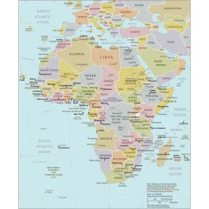
MAP / AFRICA / MADAGASCAR
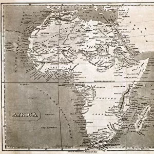
Most of the interior of the island is described as unexplored Date: mid 19th century
Mary Evans Picture Library makes available wonderful images created for people to enjoy over the centuries
Media ID 20147799
© Bubblepunk
A4 (29.7 x 21cm) Poster Print
Discover the enigmatic beauty of Madagascar with our stunning poster prints from Media Storehouse, in partnership with Mary Evans Prints Online. This captivating image, dating back to the mid-19th century, showcases a map of Africa with a detailed focus on the unique island of Madagascar. With most of its interior still unexplored during this time, this map transports you back to an era of adventure and discovery. Bring the mystery and allure of Madagascar into your home or office with our high-quality poster prints, perfect for adding a touch of historical intrigue and global charm to any space.
Premium quality poster prints are printed on luxurious semi-gloss satin 270 gsm paper. Our meticulously crafted poster prints offer an affordable option for decorating any space, making them ideal for living rooms, bedrooms, offices and beyond. To ensure your poster arrives in good condition, we roll and send them in strong mailing tubes.
Poster prints are budget friendly enlarged prints in standard poster paper sizes (A0, A1, A2, A3 etc). Whilst poster paper is sometimes thinner and less durable than our other paper types, they are still ok for framing and should last many years. Our Archival Quality Photo Prints and Fine Art Paper Prints are printed on higher quality paper and the choice of which largely depends on your budget.
Estimated Product Size is 21.6cm x 30.3cm (8.5" x 11.9")
These are individually made so all sizes are approximate
Artwork printed orientated as per the preview above, with landscape (horizontal) or portrait (vertical) orientation to match the source image.
FEATURES IN THESE COLLECTIONS
> Mary Evans Prints Online
> New Images July 2020
> Africa
> Madagascar
> Maps
> Africa
> Madagascar
> Related Images
> Africa
> Related Images
> Maps and Charts
> Related Images
EDITORS COMMENTS
This map print from the mid-19th century showcases the intriguing and largely unexplored interior of the island nation of Madagascar, located off the eastern coast of Africa. The map, a testament to the spirit of exploration and discovery that characterized the era, reveals the vast expanse of Madagascar's untouched territories. Madagascar, the fourth largest island in the world, has long been a subject of fascination due to its unique biodiversity and rich cultural heritage. The map highlights the various ethnic groups and territories that inhabited the island at the time, each with their distinct languages, customs, and traditions. The interior of Madagascar, depicted in this map, remains largely unexplored even today. With its diverse topography, ranging from rainforests and mountains to deserts and plateaus, the island's interior holds countless secrets waiting to be discovered. The map provides a glimpse into the unknown, with blank spaces and rough outlines indicating the vast areas yet to be explored. The cartographic details on this map are a reflection of the knowledge available during the mid-19th century. The map's borders are not definitive, and the interior is marked with rough outlines and incomplete information, reflecting the limited understanding of the island's geography at the time. The map serves as a reminder of the intrepid explorers who braved the unknown and the vast amount of knowledge that still awaits discovery. This map print is a fascinating historical artifact that transports us back in time and offers a glimpse into the unexplored interior of Madagascar during the mid-19th century. It is a reminder of the spirit of exploration and discovery that drives us to understand the world around us and the mysteries that lie within.
MADE IN AUSTRALIA
Safe Shipping with 30 Day Money Back Guarantee
FREE PERSONALISATION*
We are proud to offer a range of customisation features including Personalised Captions, Color Filters and Picture Zoom Tools
SECURE PAYMENTS
We happily accept a wide range of payment options so you can pay for the things you need in the way that is most convenient for you
* Options may vary by product and licensing agreement. Zoomed Pictures can be adjusted in the Cart.