Poster Print > Europe > Netherlands > Maps
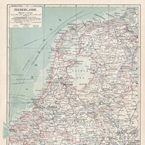
Poster Print : MAP / NETHERLANDS 1827


![]()
Poster Prints from Mary Evans Picture Library
MAP / NETHERLANDS 1827
Map of the Netherlands Date: 1827
Mary Evans Picture Library makes available wonderful images created for people to enjoy over the centuries
Media ID 20153871
© Bubblepunk
A3 (42 x 29.7cm) Poster Print
Discover the rich history of the Netherlands with our exquisite Map / Netherland 1827 poster print from Media Storehouse and Mary Evans Prints Online. This detailed and captivating antique map, dated 1827, offers a fascinating glimpse into the geography and political landscape of the Netherlands during that era. With intricate cartography and vivid colors, this poster print makes an excellent addition to any home or office space, transporting you back in time and adding a touch of history and charm to your surroundings. Order now and step into the past with Media Storehouse's exceptional range of poster prints.
Premium quality poster prints are printed on luxurious semi-gloss satin 270 gsm paper. Our meticulously crafted poster prints offer an affordable option for decorating any space, making them ideal for living rooms, bedrooms, offices and beyond. To ensure your poster arrives in good condition, we roll and send them in strong mailing tubes.
Poster prints are budget friendly enlarged prints in standard poster paper sizes (A0, A1, A2, A3 etc). Whilst poster paper is sometimes thinner and less durable than our other paper types, they are still ok for framing and should last many years. Our Archival Quality Photo Prints and Fine Art Paper Prints are printed on higher quality paper and the choice of which largely depends on your budget.
Estimated Product Size is 30.6cm x 42.6cm (12" x 16.8")
These are individually made so all sizes are approximate
Artwork printed orientated as per the preview above, with portrait (vertical) orientation to match the source image.
FEATURES IN THESE COLLECTIONS
> Mary Evans Prints Online
> New Images July 2020
> Europe
> Netherlands
> Maps
> Europe
> Netherlands
> Posters
> Europe
> Netherlands
> Related Images
> Europe
> Related Images
> Maps and Charts
> Netherlands
> Maps and Charts
> Related Images
EDITORS COMMENTS
This map print, titled "Map of the Netherlands," dates back to the year 1827, making it an intriguing window into the past. The intricately detailed map showcases the geographical features of the Netherlands during this time, with its winding waterways, dense forests, and bustling cities. The map's vibrant colors and meticulous labeling provide a visual representation of the Netherlands' political and administrative divisions, including provinces, cities, and towns. The map was produced during a significant period in Dutch history. The Napoleonic Wars had ended just a few decades prior, and the Netherlands was in the midst of a period of political and economic transformation. This map offers a snapshot of the country's borders and territories during this time, providing valuable context for students of history and cartography. The map's scale and detail make it an essential resource for anyone interested in the Netherlands and its rich history. It offers a unique perspective on the country's geography, allowing us to trace the evolution of its borders and settlement patterns over time. Additionally, the map's aesthetic appeal makes it a beautiful addition to any home or office, serving as a conversation starter and a reminder of the fascinating history of the Netherlands and Europe as a whole. This map print is a testament to the art and science of cartography during the 19th century. It reflects the advances in mapmaking techniques and the growing importance of accurate and detailed maps for both practical and intellectual pursuits. Whether used for research, education, or decoration, this map of the Netherlands from 1827 is a valuable and intriguing addition to any collection.
MADE IN AUSTRALIA
Safe Shipping with 30 Day Money Back Guarantee
FREE PERSONALISATION*
We are proud to offer a range of customisation features including Personalised Captions, Color Filters and Picture Zoom Tools
SECURE PAYMENTS
We happily accept a wide range of payment options so you can pay for the things you need in the way that is most convenient for you
* Options may vary by product and licensing agreement. Zoomed Pictures can be adjusted in the Cart.