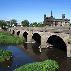
Poster Print > Europe > United Kingdom > England > Yorkshire > Wakefield
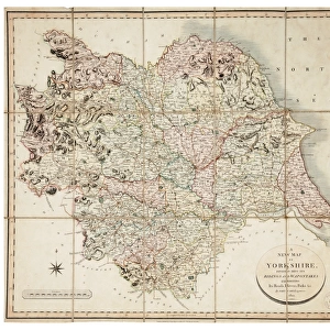
Poster Print : New map of Yorkshire divided into its Ridings, surveyed 1815-1817


![]()
Poster Prints from Sheffield City Archives
New map of Yorkshire divided into its Ridings, surveyed 1815-1817
By Christopher Greenwood.Made on the basis of triangles in the County, determined by Lieut. Col. Wm. Mudge... and Captn. Thos. Colby... in the trigonometrical survey of England by order of the Honourable Board of Ordnance and surveyed in the years 1815, 1816, and 1817.Engraved by S. Neele and Son, London; published by Robinson, Son and Holdsworth, Leeds, John Hurst and C. Greenwood, Wakefield, 4 June 1817.Original at Sheffield City Archives: SY109/Z1/1
Sheffield City Archives and Local Studies Library has an unrivalled collection of images of Sheffield, England
Media ID 14046224
© Sheffield City Council
A3 (42 x 29.7cm) Poster Print
Discover the rich history of Yorkshire with our exquisite poster prints from Media Storehouse. This captivating piece showcases an 1815-1817 map of Yorkshire, divided into its Ridings. Meticulously surveyed by Lieut. Col. Wm. Mudge and Captn. Thos. Colby, this map was created using triangles for enhanced accuracy by Christopher Greenwood. Bring the intriguing past of Yorkshire into your home or office with this beautiful and authentic wall art. Order yours today and let the story of Yorkshire unfold before your eyes.
Premium quality poster prints are printed on luxurious semi-gloss satin 270 gsm paper. Our meticulously crafted poster prints offer an affordable option for decorating any space, making them ideal for living rooms, bedrooms, offices and beyond. To ensure your poster arrives in good condition, we roll and send them in strong mailing tubes.
Poster prints are budget friendly enlarged prints in standard poster paper sizes (A0, A1, A2, A3 etc). Whilst poster paper is sometimes thinner and less durable than our other paper types, they are still ok for framing and should last many years. Our Archival Quality Photo Prints and Fine Art Paper Prints are printed on higher quality paper and the choice of which largely depends on your budget.
Estimated Product Size is 42.6cm x 30.6cm (16.8" x 12")
These are individually made so all sizes are approximate
Artwork printed orientated as per the preview above, with landscape (horizontal) orientation to match the source image.
FEATURES IN THESE COLLECTIONS
> Arts
> Artists
> G
> John Greenwood
> Arts
> Artists
> J
> John June
> Europe
> United Kingdom
> England
> Leeds
> Europe
> United Kingdom
> England
> Maps
> Europe
> United Kingdom
> England
> Sheffield
> Europe
> United Kingdom
> England
> Wakefield
> Europe
> United Kingdom
> England
> Yorkshire
> Leeds
> Europe
> United Kingdom
> England
> Yorkshire
> Related Images
> Europe
> United Kingdom
> England
> Yorkshire
> Sheffield
> Europe
> United Kingdom
> England
> Yorkshire
> Wakefield
> Sheffield City Archives
> Maps and Plans
EDITORS COMMENTS
This print showcases the "New map of Yorkshire divided into its Ridings, surveyed 1815-1817" with meticulous precision and historical significance. Created by Christopher Greenwood, this masterpiece was crafted using triangles in the County as determined by Lieut. Col. Wm. Mudge and Captn. Thos. Colby during their trigonometrical survey of England under the orders of the Honourable Board of Ordnance. Engraved by S. Neele and Son in London, this remarkable piece was published on 4 June 1817 by Robinson, Son and Holdsworth in Leeds, John Hurst in Wakefield, and C. Greenwood himself. The attention to detail is evident as every nook and cranny of Yorkshire's landscape is meticulously captured. As a testament to its historical value, this original map can be found at Sheffield City Archives under reference SY109/Z1/1 - a treasure trove for researchers delving into plans and maps from that era. The sheer magnitude of effort put into creating such an accurate representation is awe-inspiring; it serves as a window into the past when cartography was both an art form and a scientific endeavor. Whether you are an avid historian or simply appreciate the beauty inherent in old maps, this print transports you back to early 19th century Yorkshire while showcasing the incredible skill involved in charting our world's landscapes centuries ago.
MADE IN AUSTRALIA
Safe Shipping with 30 Day Money Back Guarantee
FREE PERSONALISATION*
We are proud to offer a range of customisation features including Personalised Captions, Color Filters and Picture Zoom Tools
SECURE PAYMENTS
We happily accept a wide range of payment options so you can pay for the things you need in the way that is most convenient for you
* Options may vary by product and licensing agreement. Zoomed Pictures can be adjusted in the Cart.