Home > Science > Space Exploration > Satellite Imagery
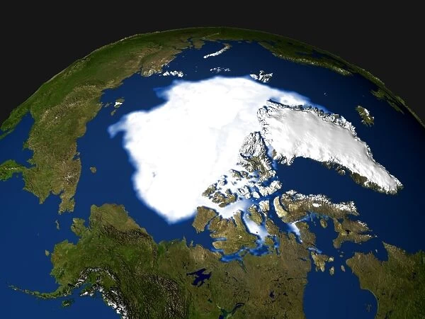
Arctic ice minimum extent, 2005
![]()

Wall Art and Photo Gifts from Science Photo Library
Arctic ice minimum extent, 2005
Arctic sea ice minimum extent, 2005. The extent of the sea ice varies over the course of a year, being largest in winter and smallest in summer. Comparing the maxima and minima over several years allows trends in the extent of the sea ice to be followed. Both the minimum and maximum extent of Arctic sea ice have reduced greatly since the middle of the 20th century, providing powerful evidence for global warming due to carbon emissions. A similar image showing the minimum extent of ice in 1979 is E205/090. E205/091 shows the minimum extent in 2003. Data from the Special Sensor Microwave Imager (SSMI) on a Defense Meteorological Support Program (DMSP) satellite
Science Photo Library features Science and Medical images including photos and illustrations
Media ID 6372713
© NASA/GODDARD SPACE FLIGHT CENTER SCIENTIFIC VISUALIZATION STUDIO/SCIENCE PHOTO LIBRARY
2005 Arctic Arctic Circle Canada Climate Change Climatological Climatology Dmsp Earth Observation Environmental Science From Space Glaciology Global Warming Greenland Ice Cap Ice Sheet Melt Melting North American North Pole Northern Polar Satellite Satellite Image Sea Ice Shrinking
EDITORS COMMENTS
This print captures the Arctic ice minimum extent in 2005, showcasing the dramatic changes occurring in our polar regions. The image reveals the varying extent of sea ice throughout the year, with its largest coverage during winter and smallest during summer. By comparing maximum and minimum extents over several years, scientists can track trends and gain valuable insights into the impact of climate change. Since the mid-20th century, both the minimum and maximum extents of Arctic sea ice have significantly decreased. This alarming reduction provides compelling evidence for global warming caused by carbon emissions. It serves as a stark reminder of how human activities are affecting our planet's delicate ecosystems. To put this image into perspective, similar photographs from 1979 and 2003 show earlier stages of diminishing ice cover. The data used to create this visual representation was collected by the Special Sensor Microwave Imager (SSMI) on a Defense Meteorological Support Program (DMSP) satellite. As we observe Earth from space through satellite imagery like this one, it becomes evident that urgent action is needed to address climate change. The shrinking Arctic ice cap not only impacts wildlife habitats but also has far-reaching consequences for global weather patterns and rising sea levels. This thought-provoking photograph highlights humanity's responsibility to protect our environment for future generations while emphasizing the importance of scientific research in understanding these complex climatological processes.
MADE IN AUSTRALIA
Safe Shipping with 30 Day Money Back Guarantee
FREE PERSONALISATION*
We are proud to offer a range of customisation features including Personalised Captions, Color Filters and Picture Zoom Tools
SECURE PAYMENTS
We happily accept a wide range of payment options so you can pay for the things you need in the way that is most convenient for you
* Options may vary by product and licensing agreement. Zoomed Pictures can be adjusted in the Cart.


