Home > Science > Space Exploration > Satellite Imagery
Martian central-peak crater floor
![]()

Wall Art and Photo Gifts from Science Photo Library
Martian central-peak crater floor
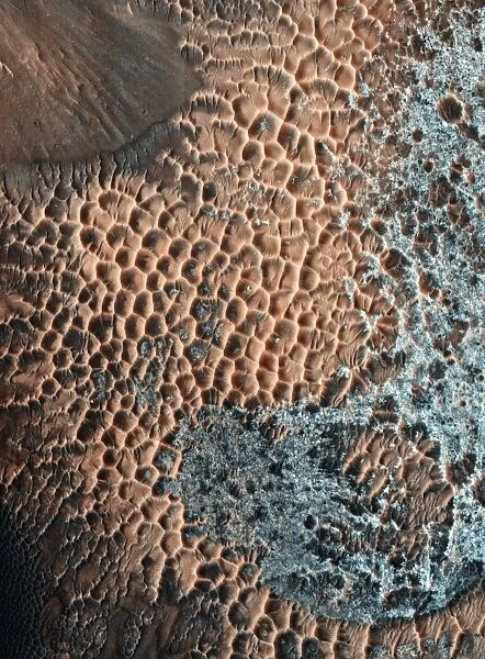
Martian central-peak crater floor, coloured satellite image. Central-peak craters form when the force of an impact causes the initial crater walls to collapse and produce a central uplift, or peak. The image shows the sand-covered surface on top of the central peak. The surface is pitted due to erosion. Image obtained by the High Resolution Imaging Science Experiment (HiRISE) camera on NASAs Mars Reconnaissance Orbiter (MRO) on 25th March 2009. The width of this image is roughly 1.2 kilometres across
Science Photo Library features Science and Medical images including photos and illustrations
Media ID 6282645
© NASA/JPL/UNIVERSITY OF ARIZONA/SCIENCE PHOTO LIBRARY
2009 Crater Eroded Erosion From Space Geological Hi Rise High Resolution Imaging Hirise Camera Impact Impact Crater Mars Mars Reconnaissance Orbiter Martian Nasa Peak Pits Pitted Planetary Science Planetary Surface Rock Sand Satellite Image Solar System Space Mission Surface Crater Floor
FEATURES IN THESE COLLECTIONS
> Science
> Space Exploration
> Satellite Imagery
EDITORS COMMENTS
This print showcases the Martian central-peak crater floor, revealing a mesmerizing landscape in stunning color. Central-peak craters are formed when the tremendous force of an impact causes the initial walls of a crater to collapse, resulting in a central uplift or peak. The image provides an extraordinary view of the sand-covered surface atop this central peak. Erosion has sculpted this unique terrain, leaving behind countless pits that dot the surface. These pitted formations bear witness to the relentless forces at play on Mars and offer insights into its geological history. Captured by NASA's Mars Reconnaissance Orbiter (MRO) using its High Resolution Imaging Science Experiment (HiRISE) camera on March 25th, 2009, this satellite image spans approximately 1.2 kilometers across. The photograph not only highlights the intricate details of erosion but also underscores humanity's ongoing exploration and scientific endeavors beyond Earth. It serves as a testament to our insatiable curiosity about our neighboring planets within our solar system. With its rich geological features and otherworldly beauty, this image from Science Photo Library invites us to marvel at the wonders of planetary science and appreciate both the vastness and intricacy of our universe.
MADE IN AUSTRALIA
Safe Shipping with 30 Day Money Back Guarantee
FREE PERSONALISATION*
We are proud to offer a range of customisation features including Personalised Captions, Color Filters and Picture Zoom Tools
SECURE PAYMENTS
We happily accept a wide range of payment options so you can pay for the things you need in the way that is most convenient for you
* Options may vary by product and licensing agreement. Zoomed Pictures can be adjusted in the Cart.

