Portugal and Spain
![]()

Wall Art and Photo Gifts from Science Photo Library
Portugal and Spain
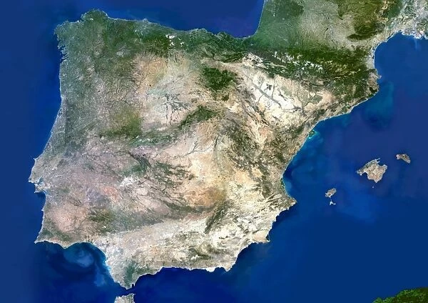
Portugal and Spain. Satellite image of the Iberian Peninsula, consisting of the European countries of Portugal and Spain. North is at top. Water is blue, vegetation is green, urban areas are grey, dry areas are brown, and shallow coastal waters are light blue. The area here is about 1375 by 975 kilometres. Portugal is a 200-kilometre wide strip along most of the western (Atlantic) coast (left). Most of Spains Atlantic coast is at upper left, and its Mediterranean coast is at right. The Spanish Balearic islands are at centre right. The Pyrenees mountains (upper right) form the border with France. Spain is dominated by a high, dusty central plateau (brown). The Straits of Gibraltar (bottom left) divide Spain from Morocco
Science Photo Library features Science and Medical images including photos and illustrations
Media ID 6350347
© PLANETOBSERVER/SCIENCE PHOTO LIBRARY
Arid Atlantic Coast Coast Line Country Dusty Earth Observation From Space Gibraltar Iberian Peninsula Island Islands Land Mediterranean Nation Plateau Portugal Portuguese Satellite Satellite Image Spain Spanish Balearic Balearics Iberia Straits
EDITORS COMMENTS
This print showcases the stunning beauty of Portugal and Spain, two European countries that share the breathtaking Iberian Peninsula. The satellite image captures a vast expanse of land, stretching approximately 1375 by 975 kilometers. With its north oriented towards the top, this aerial perspective reveals an array of vibrant colors that depict various features of the landscape. The deep blue hues represent the surrounding waters, while lush green patches symbolize abundant vegetation. Urban areas are depicted in shades of grey, contrasting with brown tones that illustrate dry regions. Along most of Portugal's western coast lies a narrow strip spanning 200 kilometers, bordered by the vast Atlantic Ocean on its left side. Spain dominates much of this image with its expansive territory. Its Atlantic coastline is visible in the upper left corner, while to the right lies its Mediterranean coast. At center-right are the Spanish Balearic islands, adding a touch of intrigue to this already mesmerizing scene. The Pyrenees mountains form a natural border between Spain and France in the upper right corner. A dusty central plateau blankets much of Spain's interior (depicted in brown), creating an arid yet strikingly beautiful landscape. Intriguingly positioned at bottom left are the Straits of Gibraltar which separate Spain from Morocco across Africa's northernmost point. This remarkable satellite image captured by Science Photo Library offers us a unique glimpse into these enchanting nations' geographical wonders and invites us to appreciate their diverse landscapes from an extraordinary vantage point above Earth's surface.
MADE IN AUSTRALIA
Safe Shipping with 30 Day Money Back Guarantee
FREE PERSONALISATION*
We are proud to offer a range of customisation features including Personalised Captions, Color Filters and Picture Zoom Tools
SECURE PAYMENTS
We happily accept a wide range of payment options so you can pay for the things you need in the way that is most convenient for you
* Options may vary by product and licensing agreement. Zoomed Pictures can be adjusted in the Cart.

