Home > Stocktrek Images > Space
The Alaskan Peninsula and Aleutian Islands
![]()

Wall Art and Photo Gifts from Stocktrek
The Alaskan Peninsula and Aleutian Islands
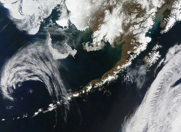
May 3, 2009 - The Alaskan Peninsula and Aleutian Islands. The Aleutians are a chain of islands that extend from Alaska toward the Kamchatka Peninsula in Russia. The corner of mainland Alaska is visible on the right side of the image and the islands wrap diagonally across the bottom half of the image. The Bering Sea dominates the upper left half of the image, and the Northern Pacific Ocean dominates the bottom right half. Kodiak Island is visible near the right center of the image between the mainland and the cloud cover over the Northern Pacific. These Aleutian Islands are part of the Pacific Ring of Fire, a zone of volcanic activity caused by the shifting and moving of the Earths crust
Stocktrek Images specializes in Astronomy, Dinosaurs, Medical, Military Forces, Ocean Life, & Sci-Fi
Media ID 13063829
© Stocktrek Images
Alaska Aleutian Arc Aleutian Islands Archipelago Geography Island Land Feature Landform Mountain Range Pacific Pacific Ocean Peninsula Ring Of Fire Satellite View Topography Volcanic Volcano Aleutian Barents Sea Kodiak Mainland
FEATURES IN THESE COLLECTIONS
> Europe
> Russia
> Heritage Sites
> Volcanoes of Kamchatka 20
EDITORS COMMENTS
This print showcases the breathtaking beauty of the Alaskan Peninsula and Aleutian Islands. Taken on May 3,2009, from a satellite view in space, it offers a mesmerizing perspective of this remote region. The Aleutians, an archipelago stretching from Alaska towards Russia's Kamchatka Peninsula, dominate the bottom half of the image as they wrap diagonally across it. In this stunning composition, we can see mainland Alaska on the right side while cloud cover blankets parts of the Northern Pacific Ocean. Kodiak Island stands out near the center-right between the mainland and the vast expanse of ocean. These islands are part of the Pacific Ring of Fire – a zone known for its volcanic activity caused by tectonic plate movements. The photograph highlights various geographical features such as mountains ranges and landforms that make up these islands' rugged terrain. The Bering Sea occupies much of the upper left portion while glimpses of other bodies like Barents Sea add to its grandeur. With no human presence captured in this shot, nature takes center stage here. The vivid colors and horizontal composition enhance our appreciation for this unique corner of our planet. This print is perfect for those who admire geography, topography or have an interest in volcanoes and land formations found within Earth's dynamic crust.
MADE IN AUSTRALIA
Safe Shipping with 30 Day Money Back Guarantee
FREE PERSONALISATION*
We are proud to offer a range of customisation features including Personalised Captions, Color Filters and Picture Zoom Tools
SECURE PAYMENTS
We happily accept a wide range of payment options so you can pay for the things you need in the way that is most convenient for you
* Options may vary by product and licensing agreement. Zoomed Pictures can be adjusted in the Cart.

