
Maps Tote Bag Collection
Discover the beauty and rich cultural heritage of Zimbabwe with our Maps of Zimbabwe collection of tote bags from Media Storehouse. Each tote bag features an intricately detailed map of Zimbabwe, showcasing its diverse landscapes, major cities, and historical sites. Made from high-quality, durable materials, these tote bags are perfect for everyday use or as a thoughtful gift for the traveler or history enthusiast in your life. Carry a piece of Zimbabwean history and culture with you wherever you go.
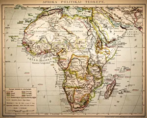
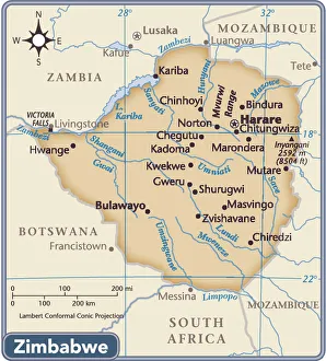
Zimbabwe, located in southern Africa
Choose a picture from our Maps Tote Bag Collection for your Wall Art and Photo Gifts
13 Tote Bags

All Professionally Made to Order for Quick Shipping
-
Maps Tote Bag Collection
Zimbabwe, located in southern Africa, is a landlocked country with an area of 390,757 square kilometers and has a diverse topography and climate which includes highlands, plateaus and lowlands. The country is home to numerous rivers, lakes and dams as well as several national parks. Zimbabwe's they can divided into eight provinces: Bulawayo, Harare (the capital city), Manicaland, Mashonaland Central, Mashonaland East, Mashonaland West Masvingo and Matabeleland North. Each province has its own distinct geographical features such as mountains ranges or rivers that divide them from one another. In addition to these provinces there are also several cities in Zimbabwe that have their own unique maps including Victoria Falls which is known for its spectacular waterfalls. Maps of Zimbabwe can be found online or purchased from local stores in the country itself. They provide an invaluable resource for travelers looking to explore this beautiful African nation.
+
Our beautiful pictures are available as Framed Prints, Photos, Wall Art and Photo Gifts
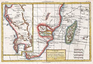
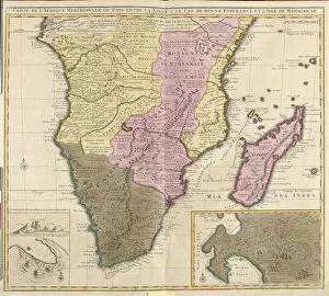
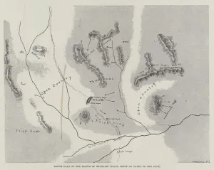
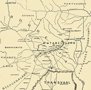
The Maps of Zimbabwe Africa collection from Media Storehouse is a stunning compilation of vintage maps that showcase the intricate details and beauty of Zimbabwe. Our collection features an array of maps dating back to the 1800s, highlighting the country's rich history and cultural heritage. Each map in our collection has been carefully curated to provide a unique perspective on Zimbabwe's geography, topography, and landmarks. These wall art and framed prints are perfect for anyone looking to add a touch of sophistication and elegance to their home or office decor. The Maps of Zimbabwe Africa collection offers something for everyone, whether you're interested in exploring the country's natural wonders or its bustling cities. Our collection is a must-have for anyone who appreciates fine art and wants to celebrate the beauty of Zimbabwe. With its high-quality prints and attention to detail, it's no wonder why these maps have become so popular among collectors around the world.
+
What are Maps of Zimbabwe Africa art prints?
Maps of Zimbabwe Africa art prints are high-quality reproductions of maps that depict the geography and topography of Zimbabwe, a landlocked country located in southern Africa. These prints showcase the intricate details and features of the region, including its cities, rivers, mountains, and other landmarks. These art prints are perfect for those who have an interest in African geography or history. They can be used to decorate homes or offices with a unique touch that reflects one's passion for exploring new places. Additionally, these maps make great educational tools for students studying African geography or history. We offer a wide range of Maps of Zimbabwe Africa art prints that come in various sizes and styles to suit different preferences. Whether you prefer vintage-style maps or contemporary designs, there is something for everyone at Media Storehouse. These prints are produced using high-quality materials to ensure they last long without fading or losing their vibrancy over time.
+
What Maps of Zimbabwe Africa art prints can I buy from Media Storehouse?
We offer a wide variety of Maps of Zimbabwe Africa art prints that you can choose from. These maps showcase the different regions, cities and landmarks in Zimbabwe, highlighting its rich history and culture. You can find vintage maps dating back to the 1800s or modern-day satellite imagery showcasing the country's natural beauty. Some of the popular options include detailed topographical maps, political maps showing boundaries and administrative divisions, and road maps displaying major highways and routes. Additionally, there are artistic renditions featuring vibrant colors and intricate details that would make great additions to any home or office decor. Whether you're looking for a map as a gift for someone special or simply want to decorate your own space with something unique, we have got you covered. With our extensive collection of Maps of Zimbabwe Africa art prints available in various sizes and formats such as canvas prints or framed posters, finding the perfect piece is easy.
+
How do I buy Maps of Zimbabwe Africa art prints?
To buy Maps of Zimbabwe Africa art prints, you can visit our online store. We offer a wide range of high-quality art prints that are perfect for decorating your home or office space. You can browse through our collection of Maps of Zimbabwe Africa art prints and choose the one that best suits your taste and preferences. Once you have selected the print you want to purchase, simply add it to your cart and proceed to checkout. At this point, you will be prompted to provide your shipping information and payment details. We accept various payment methods including credit cards, PayPal, and Apple Pay. Once your order is confirmed, they will process it promptly and ship it out to you as soon as possible. Buying Maps of Zimbabwe Africa art prints from Media Storehouse is a simple and hassle-free process that allows you to enjoy beautiful artwork in the comfort of your own home or office.
+
How much do Maps of Zimbabwe Africa art prints cost?
We offer a wide range of Maps of Zimbabwe Africa art prints that vary in price depending on the size and type of print. Our collection includes high-quality paper prints, canvas prints, and framed prints that are perfect for decorating your home or office space. The cost of our Maps of Zimbabwe Africa art prints is competitive with other online retailers and reflects the quality and uniqueness of each piece. We take pride in offering affordable prices without compromising on quality or customer service. Our team works hard to ensure that all orders are processed quickly and efficiently so you can enjoy your new artwork as soon as possible. Whether you're looking for a small print to add some color to your room or a large statement piece for your living room, we have something for everyone at Media Storehouse.
+
How will my Maps of Zimbabwe Africa art prints be delivered to me?
We take great care in delivering your Maps of Zimbabwe Africa art prints to you. We use high-quality packaging materials to ensure that your print arrives in perfect condition. Our standard delivery method is through a trusted courier service, who will deliver your print directly to your doorstep. We also offer international shipping options for our customers outside of the UK. Depending on the destination country and size of the package, we may use different delivery methods such as air freight or sea freight. Once your order has been dispatched from our warehouse, you will receive an email notification with tracking information so that you can keep track of its progress until it reaches you. We are committed to providing excellent customer service and ensuring that every aspect of your purchase experience is smooth and hassle-free.