Home > Arts > Artists > H > Henricus Hondius
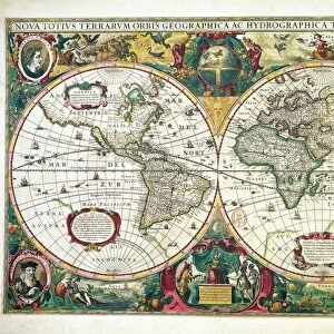
Map of the Americas by Henricus Hondius, 1631

![]()
Wall Art and Photo Gifts from Universal Images Group (UIG)
Map of the Americas by Henricus Hondius, 1631
Cartography, 17th century. Map of the Americas by Henricus Hondius, 1631
Universal Images Group (UIG) manages distribution for many leading specialist agencies worldwide
Media ID 9570571
© DEA PICTURE LIBRARY
17th Century Atlantic Ocean Coastline Direction Guidance Navigation Pacific Ocean Sailing Ship South America Western Script
FEATURES IN THESE COLLECTIONS
> Arts
> Artists
> H
> Henricus Hondius
> North America
> Related Images
> South America
> Related Images
> Universal Images Group (UIG)
> Art
> Painting, Sculpture & Prints
> Cartography
EDITORS COMMENTS
This print showcases the exquisite "Map of the Americas" created by Henricus Hondius in 1631. A true masterpiece of 17th-century cartography, this map offers a fascinating glimpse into the navigational knowledge and artistic skill of that era. With its intricate details and precise measurements, Hondius's map provides a comprehensive depiction of both North and South America. The Atlantic Ocean dominates the eastern side, while on the western side lies the vast expanse of the Pacific Ocean. This beautifully illustrated piece serves as a valuable tool for understanding historical navigation techniques and physical geography. The inclusion of sailing ships further emphasizes the importance of sea travel during this period. As one gazes upon this artwork, it is easy to imagine intrepid explorers using maps like these to guide their journeys across uncharted waters. Hondius's attention to detail extends beyond geographical accuracy; his artistry shines through in every stroke. The delicate coastline contours, Western script labels, and subtle shading all contribute to making this map an exceptional example of illustration and painting from centuries ago. Whether you are a history enthusiast or simply appreciate fine craftsmanship, this horizontal print transports you back in time to an age when exploration was at its peak. Immerse yourself in this remarkable piece that captures not only our continents' physical features but also echoes humanity's insatiable thirst for discovery.
MADE IN AUSTRALIA
Safe Shipping with 30 Day Money Back Guarantee
FREE PERSONALISATION*
We are proud to offer a range of customisation features including Personalised Captions, Color Filters and Picture Zoom Tools
SECURE PAYMENTS
We happily accept a wide range of payment options so you can pay for the things you need in the way that is most convenient for you
* Options may vary by product and licensing agreement. Zoomed Pictures can be adjusted in the Cart.