Home > Europe > Italy > Tuscany > Florence
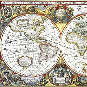
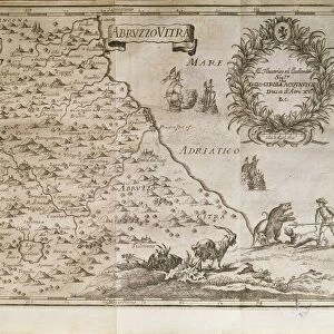
Map of Great Britain and Ireland, by Stefano Buonsignori, oil painting, 1575-1584

![]()
Wall Art and Photo Gifts from Universal Images Group (UIG)
Map of Great Britain and Ireland, by Stefano Buonsignori, oil painting, 1575-1584
Italy - Tuscany region - Florence. Palazzo Vecchio, Hall of the Geographical Maps. Map of Great Britain and Ireland, oil painting by Stefano Buonsignori 1575-1584
Universal Images Group (UIG) manages distribution for many leading specialist agencies worldwide
Media ID 9570211
© DEA / A. DAGLI ORTI
16th Century Bonsignori Stefano Great Britain Hall Of The Geographical Maps Ireland Oil Painting Palazzo Vecchio
FEATURES IN THESE COLLECTIONS
> Europe
> Italy
> Sculptures
> Europe
> Italy
> Tuscany
> Florence
> Europe
> Republic of Ireland
> Maps
> Europe
> Republic of Ireland
> Paintings
> Universal Images Group (UIG)
> Art
> Painting, Sculpture & Prints
> Cartography
EDITORS COMMENTS
This oil painting, created by Stefano Buonsignori between 1575 and 1584, transports us back to the rich history of Great Britain and Ireland in the 16th century. The intricate details and vibrant colors of this antique map offer a glimpse into the world of cartography during that era. Displayed proudly in the Palazzo Vecchio's Hall of the Geographical Maps in Florence, Italy, this masterpiece showcases Buonsignori's exceptional talent as an artist. The vertical composition allows viewers to immerse themselves in the vastness of these two lands, while also appreciating their unique geographical features. As we gaze upon this remarkable piece, it is evident that every stroke was carefully crafted with precision and dedication. The illustration captures not only the physical landscape but also provides insight into historical events and cultural influences that shaped both nations at that time. The absence of people within this artwork invites us to reflect on how landscapes can stand alone as powerful symbols of heritage and identity. It reminds us that maps are not merely tools for navigation but windows into our collective past. This print from Universal Images Group (UIG) serves as a testament to Buonsignori's artistic genius and his contribution to preserving our understanding of Great Britain and Ireland's history. Let it transport you through time as you explore these ancient lands through his eyes.
MADE IN AUSTRALIA
Safe Shipping with 30 Day Money Back Guarantee
FREE PERSONALISATION*
We are proud to offer a range of customisation features including Personalised Captions, Color Filters and Picture Zoom Tools
SECURE PAYMENTS
We happily accept a wide range of payment options so you can pay for the things you need in the way that is most convenient for you
* Options may vary by product and licensing agreement. Zoomed Pictures can be adjusted in the Cart.