Home > Europe > Netherlands > Maps
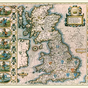
Map of the Dutch Republic, Amsterdam, 1658. Netherlands

![]()
Wall Art and Photo Gifts from Universal Images Group (UIG)
Map of the Dutch Republic, Amsterdam, 1658. Netherlands
Universal Images Group (UIG) manages distribution for many leading specialist agencies worldwide
Media ID 9757789
© Universal History Archive/Universal Images Group
1658 Amsterdam Dutch Netherlands Republic
FEATURES IN THESE COLLECTIONS
> Europe
> Netherlands
> Amsterdam
> Europe
> Netherlands
> Maps
> Universal Images Group (UIG)
> History
> Art
EDITORS COMMENTS
This print showcases a remarkable piece of history - the Map of the Dutch Republic, Amsterdam in 1658. Transporting us back to the Golden Age of the Netherlands, this meticulously detailed cartographic masterpiece offers a glimpse into the flourishing city of Amsterdam during its prime. The map depicts an intricate network of canals and waterways that crisscross through the vibrant streets, revealing Amsterdam's unique layout as a hub for trade and commerce. Every street corner is meticulously labeled, capturing the essence of this bustling metropolis at its zenith. With skilled artistry evident in every stroke, this print not only serves as a historical document but also as an exquisite work of art. The delicate lines and vibrant colors bring life to each building and landmark depicted on this map. It is truly a testament to both the skillful craftsmanship of cartographers from centuries past and their dedication to preserving knowledge through visual representation. As we gaze upon this extraordinary piece, we are transported back in time - imagining ourselves strolling along those very streets or navigating those winding canals. This photograph allows us to appreciate not only Amsterdam's rich history but also its enduring legacy as one of Europe's most culturally significant cities. Whether you are an avid collector or simply fascinated by history, this print from Universal Images Group (UIG) is sure to be a cherished addition to any space – offering endless opportunities for exploration and discovery within one frame.
MADE IN AUSTRALIA
Safe Shipping with 30 Day Money Back Guarantee
FREE PERSONALISATION*
We are proud to offer a range of customisation features including Personalised Captions, Color Filters and Picture Zoom Tools
SECURE PAYMENTS
We happily accept a wide range of payment options so you can pay for the things you need in the way that is most convenient for you
* Options may vary by product and licensing agreement. Zoomed Pictures can be adjusted in the Cart.